NOAA National Hurricane Center Tropical Storm Arthur 2026 Projected Path
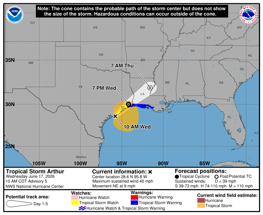
MIAMI, Florida – NOAA‘s National Hurricane Center issued Public Advisory #6 at 11:30 a.m. Central Daylight Time (12:30 p.m. Eastern Daylight Time) on Wednesday, June 17, 2026, for Tropical Storm Arthur, the first named storm of the 2026 Atlantic Hurricane Season, which developed from Potential Tropical Cyclone One (formerly Invest 90L) near the middle Texas coast.
A Tropical Storm Warning is in effect from Sargent, Texas to Morgan City, Louisiana.
Tropical Storm Arthur is located near latitude 28.8 North, longitude 95.5 West, about 60 miles (100 km) east-northeast of Port O’Connor, Texas, and about 165 miles (265 km) west-southwest of Lake Charles, Louisiana. It is moving toward the northeast at 9 mph (15 km/h).
An increase in forward speed is expected today. On the official NHC forecast track, the center is expected to move northeastward along the Texas coast today and then move inland over southwestern Louisiana by tonight or early Thursday.
Computer models (spaghetti models) show Tropical Storm Arthur continuing northeastward along or just offshore the eastern Texas coast before moving inland over extreme eastern Texas or southwestern Louisiana. Model guidance is in general agreement on this track through the next couple of days.
Both the GFS (American model) and ECMWF (European model) support a track that keeps the system close to the Texas coast before moving it onshore late Wednesday or early Thursday. The official NHC forecast track is consistent with the latest dynamical model consensus.
Tropical Storm Arthur has maximum sustained winds of 45 mph (75 km/h), with higher gusts. Tropical-storm-force winds extend outward up to 175 miles (280 km) from the center. Minimum central pressure is 999 mb.
Little change in strength is expected before the center moves inland. Weakening is anticipated once the storm moves over land, and it could dissipate by tonight or early Thursday.
The main threat from Arthur is life-threatening flash flooding. The system is expected to produce rainfall totals of 5 to 10 inches, with isolated totals near 20 inches, through early Friday across portions of the Mid and Upper Texas coast, southern and central Louisiana, Mississippi, Alabama, western Georgia, and the Florida Panhandle.
A storm surge of 2 to 4 feet is possible from Port Bolivar, Texas to Morgan City, Louisiana. A couple of tornadoes are also possible through Thursday from the Upper Texas Coast into southern Louisiana, Mississippi, Alabama, and the western Florida Panhandle. Life-threatening surf and rip currents are expected along the northwestern Gulf Coast.
NOAA forecasts a “below-normal” 2026 Atlantic Hurricane Season, which runs from June 1 through November 30.
Although peak hurricane season isn’t until September 10, hurricane and tropical storm activity begins to pick up in late June, according to NOAA and the National Weather Service’s historical hurricane activity data. Tropical Storm Arthur is the first named storm of the 2026 Atlantic hurricane season.
Copyright 2023-2025 FloridaWord.com


