NOAA National Hurricane Center Potential Tropical Cyclone One Projected Path
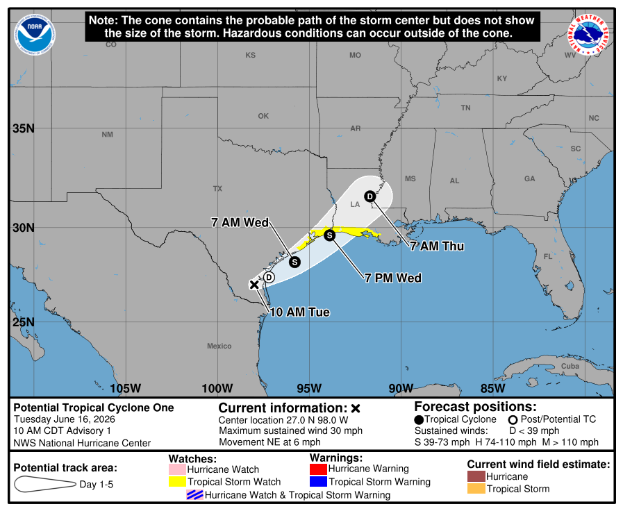
MIAMI, Florida – NOAA‘s National Hurricane Center issued a Public Advisory at 11:00 a.m. Eastern Daylight Time on Tuesday, June 16, 2026, for Potential Tropical Cyclone One, which is developing from Invest 90L while moving northeastward near eastern Texas.
A Tropical Storm Watch has been issued for the northwestern Gulf Coast from Sargent, Texas to Morgan City, Louisiana.
Potential Tropical Cyclone One is located near latitude 27.0 North, longitude 98.0 West, about 65 miles southwest of Corpus Christi, Texas, and is moving to the northeast at 6 mph (9 km/h).
NHC forecasters say that this general motion with an increase in forward speed is anticipated over the next couple of days.
On the official NHC forecast track, the center of the system should move offshore of the Texas coast tonight or early Wednesday, move roughly parallel to the upper Texas coast later on Wednesday, and move back inland in extreme eastern Texas or southwestern Louisiana late Wednesday or early Thursday.
Computer models, often referred to as spaghetti models, show Potential Tropical Cyclone One moving northeastward along the eastern Texas coast towards southwestern Louisiana, with models in general agreement through the weekend.
Both the GFS (American model) and ECMWF (European model) are in general agreement with this track for the first 72 hours.
Model guidance hugs the Texas coast but generally keeps it offshore for about a day on Wednesday before moving back onshore late Wednesday or early Thursday.
The official NHC forecast track is between the latest dynamical model consensus and the corrected-model consensus HCCA.
Potential Tropical Cyclone One has maximum sustained winds of 30 mph (45 km/h), with higher gusts.
The disturbance is forecast to gradually strengthen and could become a tropical storm early on Wednesday. Weakening is anticipated on Thursday after the system moves back inland.
NOAA forecasts a “below-normal” 2026 Atlantic Hurricane Season, which runs from June 1 through November 30.
Although peak hurricane season isn’t until September 10, hurricane and tropical storm activity begins to pick up in late June, according to NOAA and the National Weather Service’s historical hurricane activity data.
Copyright 2023-2025 FloridaWord.com


