NOAA National Hurricane Center Tropical Weather Outlook for June 16, 2026.
MIAMI, Florida – NOAA‘s National Hurricane Center in Miami, Florida, issued a Tropical Weather Outlook at 8 AM Eastern Daylight Time on Tuesday, June 16, 2026, due to the presence of Invest 90L that may form into a tropical cyclone within the next 7 days over Texas.
If this system develops into a tropical storm or hurricane, the next name on the 2026 Atlantic Hurricane List is Arthur.
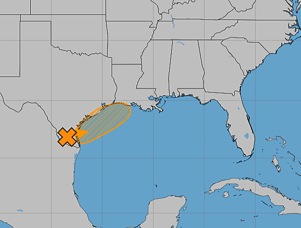
Invest 90L (marked with an orange shaded area) is a broad area of low pressure located inland over south Texas that is producing a large area of disorganized showers and thunderstorms.
NHC forecasters say that Invest 90L will likely move northeastward along the Texas coast and could emerge over the northwestern Gulf of America later today or tonight. Environmental conditions are expected to be marginally conducive for the formation of a short-lived tropical storm late today or on Wednesday, especially if the system moves far enough offshore.
Regardless of tropical cyclone formation, interests across southern and eastern Texas and portions of Louisiana and Mississippi should prepare for periods of intense rainfall over the next several days which could produce widespread, life-threatening flash, urban, and river flooding.
Gusty winds and coastal flooding are also possible along portions of the northwestern Gulf Coast, and Tropical Storm Watches or Warnings could be required later today.
This system has a 60% chance of tropical cyclone formation within the next 7 days and a 60% chance within the next 48 hours.
Computer models, often referred to as spaghetti models, show Invest 90L moving to the northeast over southern and eastern Texas over the next few days.
Both the GFS (American model) and ECMWF (European model) are in general agreement with this track for the first 72 hours.
NOAA forecasts a “below-normal” 2026 Atlantic Hurricane Season, which runs from June 1 through November 30.
Although peak hurricane season isn’t until September 10, hurricane and tropical storm activity begins to pick up in late June, according to NOAA and the National Weather Service‘s historical hurricane activity data.
Copyright 2023-2025 FloridaWord.com


