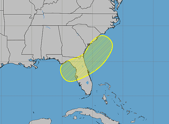
NOAA National Hurricane Center Tropical Weather Outlook at 8:00 AM Eastern Daylight Time on Wednesday, July 15, 2026,
MIAMI, Florida – NOAA‘s National Hurricane Center in Miami, Florida, issued a Tropical Weather Outlook at 8:00 AM Eastern Daylight Time on Wednesday, July 15, 2026, due to an area of low pressure that is expected to form in the northeastern Gulf of Mexico this weekend.
If this system develops into a tropical storm or hurricane, the next name on the 2026 Atlantic Hurricane List is Bertha.
A low pressure area is forecast to form during the weekend over the northeastern Gulf of Mexico. Subsequent slow development of this system is possible while it moves slowly northeastward over the northeastern Gulf and/or near the southeastern coast of the United States by early next week.
NHC forecasters say that environmental conditions are predicted to remain only marginally conducive for significant development in the near term.
This system has a near 0% chance of tropical cyclone formation within the next 48 hours and a 20% chance within the next 7 days.
NOAA forecasts a “below-normal” 2026 Atlantic Hurricane Season, which runs from June 1 through November 30.
Although peak hurricane season isn’t until September 10, hurricane and tropical storm activity is possible throughout July and typically increases as the season progresses toward its climatological peak in mid-September, according to NOAA and the National Weather Service‘s historical hurricane activity data.
Copyright 2023-2025 FloridaWord.com