NOAA National Hurricane Center Tropical Weather Outlook for June 18, 2026.
MIAMI, Florida – NOAA‘s National Hurricane Center in Miami, Florida, issued a Tropical Weather Outlook at 2 PM Eastern Daylight Time on Thursday, June 18, 2026, regarding the remnants of Tropical Storm Arthur.
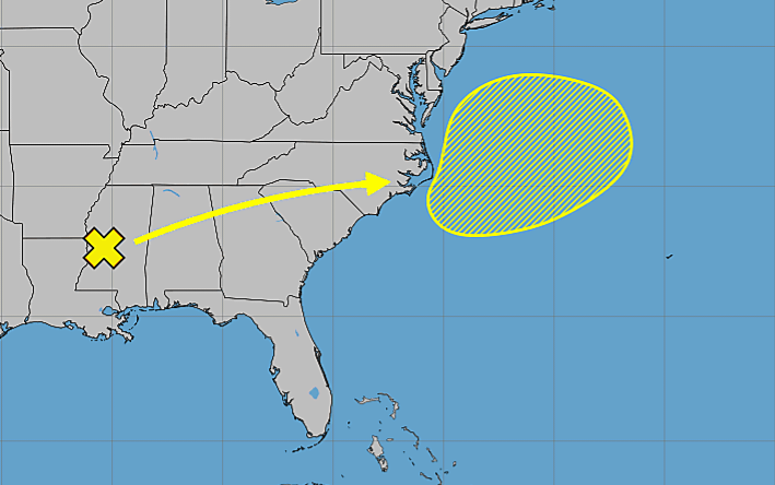
Tropical Storm Arthur, the first named storm of the 2026 Atlantic hurricane season, formed on June 17 from the earlier system near the Texas coast. It brought heavy rainfall and flooding to portions of southern and eastern Texas, Louisiana, and adjacent areas before weakening into a remnant low.
The system is now a trough of low pressure (the remnants of Arthur) located over the southeastern United States. The system is expected to emerge offshore the east coast of the United States on Friday. Environmental conditions then appear to be marginally conducive for some subtropical or tropical development on Friday or Saturday as the system moves northeastward at 15 to 20 mph across the Western Atlantic Ocean.
If this system develops into a tropical storm or hurricane, it would retain the name Arthur (per NHC naming rules for regenerated remnants).
Regardless of development, heavy rainfall with the potential for widespread and life-threatening flash flooding is likely across portions of the Southeast United States during the next day or two. Additional information on the rainfall potential can be found in rainfall forecasts and Excessive Rainfall Outlooks from the Weather Prediction Center online at www.wpc.ncep.noaa.gov.
This system has a 10% chance of tropical cyclone formation within the next 48 hours and a 10% chance within the next 7 days.
NOAA forecasts a “below-normal” 2026 Atlantic Hurricane Season, which runs from June 1 through November 30.
Although peak hurricane season isn’t until September 10, hurricane and tropical storm activity begins to pick up in late June, according to NOAA and the National Weather Service‘s historical hurricane activity data.
Copyright 2023-2025 FloridaWord.com

