MIAMI, Florida – NOAA‘s National Hurricane Center in Miami, Florida, issued a Tropical Weather Outlook at 8 a.m. Eastern Daylight Time on Tuesday, September 3, 2024, due to the presence of three systems that may form into tropical cyclones within the next 7 days.
The first system (marked with an orange “X” near the Dominican Republic) is a tropical wave that is producing disorganized showers and thunderstorms over Hispaniola and portions of the central Caribbean Sea.
NHC forecasters say that this system is expected to move westward, and a tropical depression could form when it reaches the western Caribbean Sea and the southwestern Gulf of Mexico late this week or over the weekend.
This system has a 40% chance of tropical cyclone formation within the next 7 days and a near 0% chance within the next 48 hours.
The second system (marked with a yellow “X”) is a tropical wave located about midway between the west coast of Africa and the Lesser Antilles that is producing disorganized showers and thunderstorms.
According to NOAA, some slow development is possible during the next couple of days while the system moves west-northwestward. By the end of the week, however, environmental conditions are expected to become unfavorable for additional development.
This system has a 10% chance of tropical cyclone formation within the next 7 days and a 10% chance within the next 48 hours.
The third system (marked with an orange “X” near Africa) is a tropical wave over the far eastern Atlantic that is producing disorganized showers and thunderstorms.
Environmental conditions are forecast to become a little more conducive for development, and a tropical depression could form later this week while the disturbance moves slowly west-northwestward or northwestward over the eastern tropical Atlantic Ocean.
This system could produce areas of heavy rain and gusty winds across portions of the Cabo Verde Islands in a day or two.
This system has a 40% chance of tropical cyclone formation within the next 7 days and a 10% chance within the next 48 hours.
If any of these systems develop into a tropical storm or hurricane, the next name on the 2024 Atlantic Hurricane List is Francine.
NOAA and Colorado State University forecast an “extremely active” 2024 Atlantic Hurricane Season, which runs from June 1 through November 30.
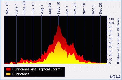
| NOAA historical hurricane data. Peak season and storm frequency. |
Peak hurricane season is September 10, according to NOAA and the National Weather Service‘s historical hurricane a4ctivity data.
Copyright 2023-2025 FloridaWord.com