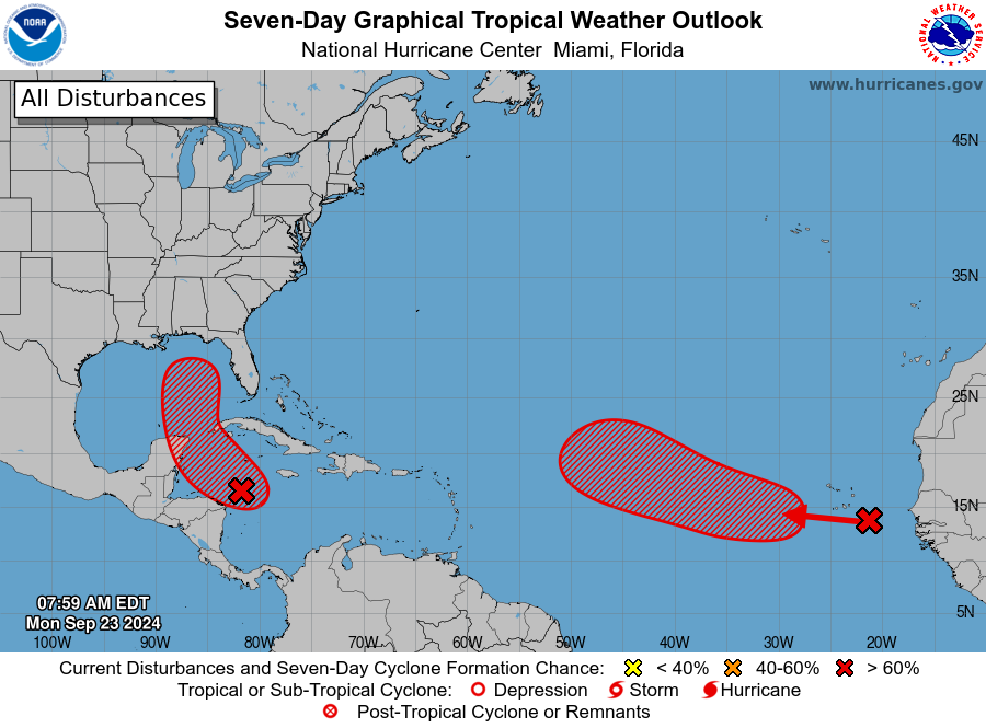
MIAMI, Florida – NOAA‘s National Hurricane Center in Miami, Florida, issued a Tropical Weather Outlook update at 8 a.m. Eastern Daylight Time on Monday, September 23, 2024, due to the presence of Invest 97L, which is likely to form into a tropical cyclone within the next 48 hours over the northwestern Caribbean Sea and Gulf of Mexico.
If this system develops into a tropical storm or hurricane, the next name on the 2024 Atlantic Hurricane List will be Helene.
Invest 97L (marked with a red “X” near Honduras) is a very broad area of low pressure that is producing organized showers and thunderstorms over the northwestern Caribbean Sea.
NHC forecasters indicate that environmental conditions appear favorable for further development of this system.
A tropical depression or storm is likely to form within the next day or two as the system moves northward across the northwestern Caribbean Sea and into the southeastern Gulf of Mexico, where additional development is expected.
Regardless of development, this system is expected to produce heavy rains over portions of Central America during the next several days.
Interests in the northwestern Caribbean, the Yucatán Peninsula of Mexico, and western Cuba should closely monitor the progress of this system, as watches or warnings will likely be required later this morning for portions of these areas.
Later this week, Invest 97L is forecast to move generally northward across the eastern Gulf of Mexico, and interests along the northern and northeastern Gulf Coast should also closely monitor its progress.
This system has a 90% chance of tropical cyclone formation within the next 7 days and an 80% chance within the next 48 hours.
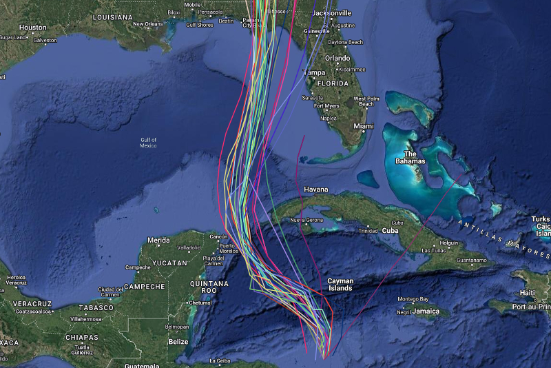
Computer models, often referred to as spaghetti models, are in strong agreement during the first 72 hours that Invest 97L will move in a general northwest direction, then northward direction between the Yucatán Peninsula and the western tip of Cuba, before shifting in a north-northeast direction toward the Florida Panhandle. Both the GFS (American model) and the ECMWF (European model) show a similar S-shaped track.
NOAA and Colorado State University forecast an “extremely active” 2024 Atlantic Hurricane Season, which runs from June 1 through November 30.
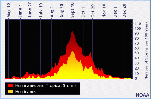
| NOAA historical hurricane data. Peak season and storm frequency. |
Peak hurricane season is September 10, according to NOAA and the National Weather Service‘s historical hurricane activity data.
Copyright 2023-2025 FloridaWord.com