
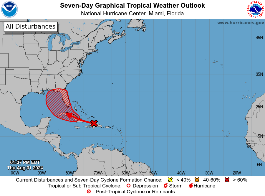
MIAMI, Florida – NOAA‘s National Hurricane Center in Miami, Florida, issued a Tropical Weather Outlook at 2 p.m. Eastern Daylight Time on Thursday, August 1, 2024, due to the presence of a system that may form into a tropical cyclone within the next 7 days over the Caribbean and then head to Florida.
The system (marked with an orange “X”) is a well-defined tropical wave that is producing a large area of disorganized showers and thunderstorms over Hispaniola, Puerto Rico, the Virgin Islands, and the adjacent waters of the southwestern Atlantic and northeastern Caribbean Sea
NHC forecasters say that development of this system should be slow to occur during the next couple of days while it moves west-northwestward over portions of the Greater Antilles.
However, environmental conditions are forecast to be more conducive for development after the wave passes the Greater Antilles, and a tropical depression could form this weekend or early next week over the eastern Gulf of Mexico or near the Florida Peninsula.
This system has a 70% chance of tropical cyclone formation within the next 7 days and a 30% chance within the next 48 hours.
Interests across the Greater Antilles, the Bahamas, and Florida should continue to monitor the progress of this system.
If this system develops into a tropical storm or hurricane, the next name on the 2024 Atlantic Hurricane List is Debby.
NOAA and Colorado State University forecast an “extremely active” 2024 Atlantic Hurricane Season, which runs from June 1 through November 30.
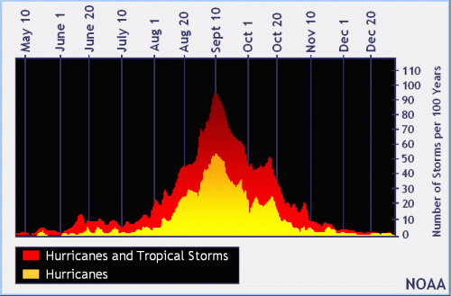 |
| NOAA historical hurricane data. Peak season and storm frequency. |
Although peak hurricane season isn’t until September 10, the end of July is when tropical storm and hurricane activity begins to pick up, according to NOAA and the National Weather Service‘s historical hurricane activity data.