MIAMI, Florida – NOAA‘s National Hurricane Center issued an updated Public Advisory at 11 p.m. Eastern Daylight Time on Tuesday, July 2, 2024, due to the presence of record-breaking Hurricane Beryl over the Caribbean, the first named hurricane of the 2024 Atlantic Hurricane Season.
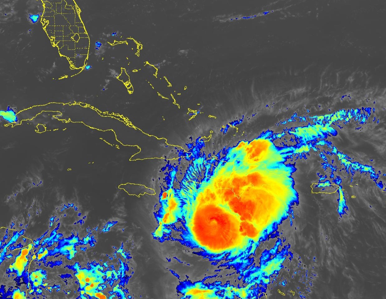
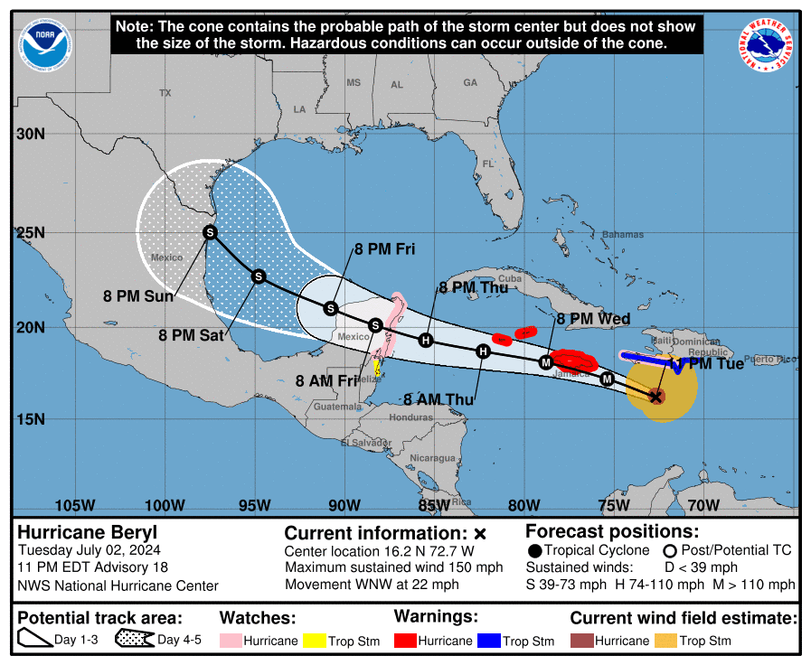
Hurricane Beryl (formerly Tropical Depression Two and Invest 95L) is located 300 miles east-southeast of Kingston, Jamaica, and is moving to the west-northwest at 22 mph (35 km/h).
NHC forecasters say that this general motion should continue through Wednesday, followed by a turn more toward the west on Wednesday night or Thursday.
On the official NHC forecast track, the center of Beryl will move quickly across the central Caribbean Sea today and is forecast to pass near Jamaica on Wednesday and the Cayman Islands on Thursday. The center is forecast to approach the Yucatan Peninsula of Mexico on Thursday night.
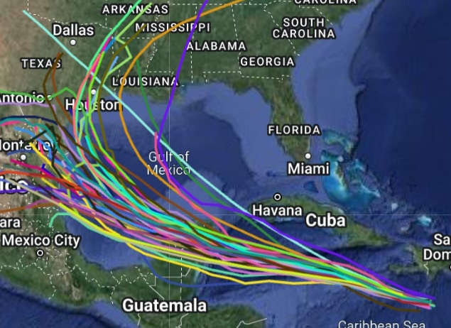
Computer models, often referred to as spaghetti models, are in general agreement that Hurricane Beryl will move west-northwest over the Caribbean.
However, there is a significant spread among the computer models (GFS-based American model, ECMWF European model, and UKMET model) after 48 hours once the tropical cyclone passes Jamaica.
Consequently, there remains considerable uncertainty in the official NHC track forecast past 72 hours.
Beryl is a category 4 hurricane on the Saffir-Simpson Hurricane Wind Scale with maximum sustained winds of 150 mph (240 km/h), with higher gusts.
Weakening should begin later today, but Beryl is still expected to be near major hurricane intensity as it moves into the central Caribbean and passes near Jamaica on Wednesday and the Cayman Islands on Thursday.
Additional weakening is expected thereafter, though Beryl is forecast to remain a hurricane in the northwestern Caribbean.
Hurricane-force winds extend outward up to 40 miles (65 km) from the center of the tropical cyclone and tropical-storm-force winds extend outward up to 185 miles (295 km).
A Hurricane Warning is in effect for Jamaica, Grand Cayman, Little Cayman, and Cayman Brac.
A Hurricane Warning means that hurricane conditions are expected somewhere within the warning area. Preparations to protect life and property should be rushed to completion.
A Hurricane Watch is in effect for the south coast of Haiti from the border with the Dominican Republic to Anse d’Hainault, and the east coast of the Yucatan Peninsula from Chetumal to Cabo Catoche.
A Hurricane Watch means that hurricane conditions are possible within the watch area. A watch is typically issued 48 hours before the anticipated first occurrence of tropical-storm-force winds, conditions that make outside preparations difficult or dangerous.
A Tropical Storm Warning is in effect for the south coast of Dominican Republic from Punta Palenque westward to the border with Haiti, and the south coast of Haiti from the border with the Dominican Republic to Anse d’Hainault.
A Tropical Storm Warning means that tropical storm conditions are expected somewhere within the warning area within 36 hours.
A Tropical Storm Watch is in effect for the coast of Belize from south of Chetumal to Belize City.
A Tropical Storm Watch means that tropical storm conditions are possible within the watch area, generally within 48 hours.
Interests elsewhere in the northwestern Caribbean Sea and the western Gulf of Mexico should closely monitor the progress of Beryl.
Hurricane Beryl has broken several records for the Atlantic Hurricane Basin.
Beryl is the easternmost hurricane to form in the tropical Atlantic during June, beating the previous record set by the 1933 Trinidad hurricane.
Beryl is the earliest Category 4 hurricane on record in the Atlantic basin, a title previously held by Hurricane Dennis on July 8, 2005.
Beryl is the strongest June hurricane in terms of wind speed, outpacing Hurricane Audrey of 1957.
Beryl is the earliest Category 5 hurricane on record, overtaking the previous record set by Hurricane Emily on July 16, 2005.
Beryl also became the strongest July hurricane ever recorded.
NOAA and Colorado State University forecast an “extremely active” 2024 Atlantic Hurricane Season, which runs from June 1 through November 30.
RELATED:
Copyright 2023-2025 FloridaWord.com