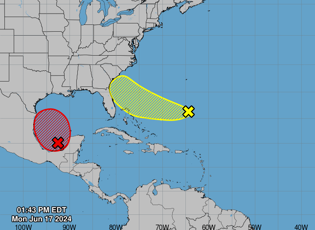
MIAMI, Florida – NOAA‘s National Hurricane Center in Miami, Florida, issued a Tropical Weather Outlook at 2 p.m. Eastern Daylight Time on Monday, June 17, 2024, due to the presence of two systems that may form into tropical cyclones within the next 7 days.
The first system (marked in yellow) is an area of cloudiness and thunderstorms located several hundred miles east of the Bahamas that is associated with a surface trough and an upper-level area of low pressure.
NHC forecasters say that some development of this system during the next few days while it moves westward or west-northwestward.
The system is forecast to approach the coast of the southeast United States on Thursday or Friday.
This system has a 30% chance of tropical cyclone formation within the next 7 days and a 10% chance within the next 48 hours.
The second system (marked in red) is a broad area of low pressure that is forming over the Bay of Campeche.
NHC forecasters say that environmental conditions appear conducive for additional gradual development, and a tropical depression or tropical storm is likely to form by midweek while it moves slowly westward or west-northwestward toward the western Gulf coast.
The second system has a 70% chance of tropical cyclone formation within the next 7 days and a 70% chance within the next 48 hours.
Regardless of development, several days of heavy rainfall are expected across portions of southern Mexico and Central America, and these rains are likely to cause life-threatening flooding and flash flooding. Locally heavy rainfall is also expected to spread over portions of the northwestern coast of the Gulf of Mexico by the middle of the week.
Interests along the western and northwestern Gulf coasts should monitor the progress of this system.
A U.S. Air Force Reserve Hurricane Hunter aircraft is en route to investigate the system.
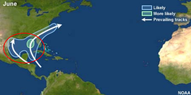
According to NOAA, most June storms begin in the northwestern Caribbean Sea or Gulf of Mexico.
| NOAA Prevailing Atlantic Hurricane Tracks June |
If either of these systems develops into a tropical storm or hurricane, the first name on the 2024 Atlantic Hurricane List is Alberto.
NOAA and Colorado State University forecast an “extremely active” 2024 Atlantic Hurricane Season, which runs from June 1 through November 30.
Copyright 2023-2025 FloridaWord.com