NOAA National Hurricane Center Tropical Weather Outlook for October 3, 2025
MIAMI, Florida – NOAA‘s National Hurricane Center in Miami, Florida, issued a Tropical Weather Outlook at 8 AM Eastern Daylight Time on Friday, October 3, 2025, due to the presence of two systems in the Atlantic including one that may develop off the coast of Florida.
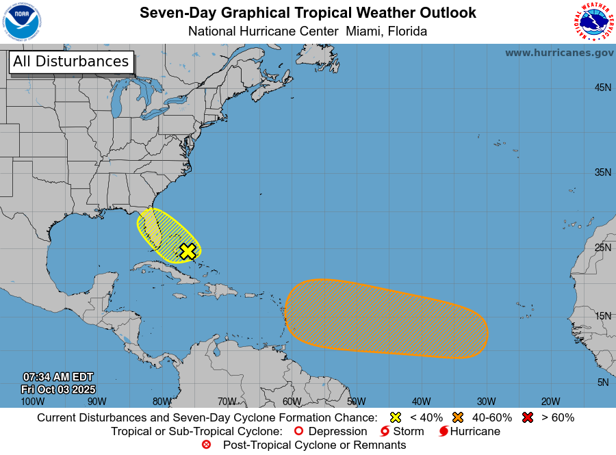
The system (marked with a yellow shaded area near Florida) is a weak area of low pressure that has formed near the central Bahamas along the remnants of a frontal boundary.
This system is expected to meander near Florida and the Bahamas for the next several days, with strong upper-level winds preventing significant development, but heavy rainfall anticipated across portions of Florida and the Bahamas through the weekend.
NHC forecasters say that environmental conditions appear marginally favorable for slow development of this system, and a tropical depression could form by the latter portion of this week or over the weekend.
This system has a 10% chance of tropical cyclone formation within the next 7 days and a 10% chance within the next 48 hours.
If this system develops into a tropical storm or hurricane, the next name on the 2025 Atlantic Hurricane List is Jerry.
In addition to this system, the NHC is monitoring a tropical wave expected to move off the coast of Africa today, interacting with another disturbance over the eastern tropical Atlantic, then moving westward, with environmental conditions becoming conducive for some slow development in a few days.
This system has a near 0% chance of formation within the next 48 hours and a 40% chance over 7 days.
NOAA forecasts an “above-normal” 2025 Atlantic Hurricane Season, which runs from June 1 through November 30.
We are now past the peak of hurricane season on September 10, but hurricane and tropical storm activity can continue well into October, according to NOAA and the National Weather Service‘s historical hurricane activity data.
Copyright 2023-2025 FloridaWord.com

