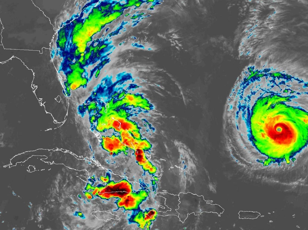
NOAA GOES East Satellite Imagery of Tropical Depression Nine and Florida September 28, 2025
ORLANDO, Florida – The National Weather Service Melbourne has issued a forecast for Central Florida on Sunday, September 28, 2025, of scattered to numerous showers and storms from late morning through the afternoon and early evening, with a 50-70% chance of precipitation.
Winds from the east northeast at 10-15 mph are expected, with gusts up to 40-50 mph possible in storms.
Thunderstorms are capable of occasional lightning, gusty winds, and heavy rainfall which could lead to minor flooding.
Rain chances will remain elevated through Monday, around 40-70%, decreasing slightly by Tuesday to around 20-40%, while temperatures will remain near or slightly above normal. A high risk of rip currents at the beaches is in effect today, with lingering swells causing rough surf of around 6-10 feet and hazardous boating conditions today. Small craft should exercise caution, with seas 8-12 feet nearshore and 12-18 feet offshore.
Near normal temperatures with highs in the upper 80s to low 90s continue, resulting in peak afternoon heat indices up to around 95-102 degrees today.
There is currently one active tropical cyclone in the Atlantic basin: Tropical Depression Nine in the central subtropical Atlantic, moving northward with potential threat to Florida. The National Hurricane Center indicates no tropical cyclone formation is expected during the next 7 days. Coastal impacts from lingering swells, including high rip current risk, rough surf up to 10 feet, minor beach erosion, and hazardous boating conditions will continue today.
Today
Showers and thunderstorms likely, mainly between 2pm and 5pm. Partly sunny, with a high near 89°F. East northeast wind 10 to 15 mph. Chance of precipitation is 60%. High risk of rip currents at the beaches.
Tonight
A chance of showers and thunderstorms before 3am, then a slight chance of showers between 3am and 4am. Mostly cloudy, with a low around 74°F. Northeast wind around 10 mph. Chance of precipitation is 30%.
Monday
A chance of showers between 8am and 11am, then a chance of showers and thunderstorms after 11am. Mostly sunny, with a high near 85°F. Heat index values as high as 98°F. North wind 10 to 15 mph, with gusts as high as 25 mph. Chance of precipitation is 50%.
Monday Night
A slight chance of showers and thunderstorms before 11pm, then a slight chance of showers between 11pm and 2am. Mostly cloudy, with a low around 74°F. Northwest wind around 15 mph, with gusts as high as 20 mph. Chance of precipitation is 20%.
Copyright 2023-2025 FloridaWord.com


