NOAA National Hurricane Center Tropical Weather Outlook for September 16, 2025.
MIAMI, Florida – NOAA‘s National Hurricane Center in Miami, Florida, issued a Tropical Weather Outlook at 2 p.m. Eastern Daylight Time on Tuesday, September 16, 2025, due to the presence of Invest 92L located over the central tropical Atlantic.
If Invest 92L develops into a tropical storm or hurricane, the next name on the 2025 Atlantic Hurricane List is Gabrielle.
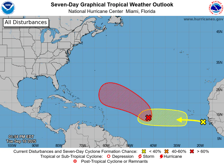
Invest 92L is an elongated area of low pressure located about midway between the Windward Islands and the Cabo Verde Islands (marked with a red shaded area).
NHC forecasters say that showers and thunderstorms associated with Invest 92L have become better organized since yesterday.
Environmental conditions are conducive for additional development, and a tropical depression or storm is likely to form in the next day or two as the system moves west-northwestward or northwestward at 10 to 15 mph over the central tropical Atlantic.
This system has a 90% chance of tropical cyclone formation within the next 7 days and a 90% chance within the next 48 hours.
Computer models, often referred to as spaghetti models, are in general agreement during the first 24 hours that the system will move west-northwestward across the tropical Atlantic.
After 24 hours, the models show the system curving northward, directed by environmental conditions and steering winds north of the Caribbean and away from the U.S.
Recent model runs, including the European model (ECMWF) and its AI variant (AIFS), along with the GFS (American model) and CMC, indicate consistent development. Forecasts suggest Invest 92L could become a major hurricane (Category 3 or higher) in the central Atlantic within 7-9 days, with development into a tropical depression or storm, possibly Gabrielle, by the weekend (September 20-21). The system is expected to remain over open waters. Intensity models vary, but many suggest it could reach hurricane strength, with some ensembles indicating major hurricane status under favorable conditions like warm sea surface temperatures.
Recent model runs show stronger development signals, with ensembles indicating a primary track recurving north into the open Atlantic, east of the U.S. East Coast. However, some uncertainty remains, and impacts cannot be totally ruled out. Outlier models suggest potential tracks closer to Bermuda, which should monitor the system.
Overall, the path and intensity remain uncertain due to model divergence, but the current consensus leans strongly toward recurvature away from major U.S. land impacts, and it is too early to determine specific effects on Florida or other U.S. areas.
NOAA forecasts an “above-normal” 2025 Atlantic Hurricane Season, which runs from June 1 through November 30.
Peak hurricane season was September 10 according to NOAA and the National Weather Service‘s historical hurricane activity data.
Copyright 2023-2025 FloridaWord.com


