NOAA’s National Hurricane Center 8 AM Tropical Weather Outlook for July 15, 2025.
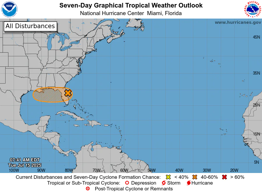
ORLANDO, Florida – NOAA‘s National Hurricane Center issued a Tropical Weather Outlook at 8 AM Eastern Daylight Time on Tuesday, July 15, 2025, due to the presence of Invest 93L that may form into a tropical cyclone within the next 7 days off the coast of Florida.
If this system develops into a tropical storm or hurricane, the next name on the 2025 Atlantic Hurricane List is Dexter.
Invest 93L (marked with an orange shaded area) is an area of low pressure located just off the Central Florida east coast.
Satellite and radar data indicate that the shower and thunderstorm activity associated with Invest 93L remains disorganized.
NHC forecasters say that Invest 93L is expected to move westward across the Florida Peninsula today and then reach the northeastern Gulf by Wednesday.
Environmental conditions appear generally favorable for additional development, and a tropical depression could form while the system moves across the northeastern and north-central Gulf.
Regardless of development, heavy rainfall could produce localized flash flooding over portions of Florida through mid-week.
Heavy rainfall could also cause flash flooding for portions of the north-central Gulf Coast during the middle to latter portions of this week.
This system has a 40% chance of tropical cyclone formation within the next 7 days and a 40% chance within the next 48 hours.
Computer models, often referred to as spaghetti models, show Invest 93L moving to the west across Central Florida, over the open waters of the Gulf of America, and then make landfall near Louisiana.
Both the GFS (American model) and ECMWF (European model) are in general agreement with this track for the first 48 hours.
NOAA forecasts an “above-normal” 2025 Atlantic Hurricane Season, which runs from June 1 through November 30.
Although peak hurricane season isn’t until September 10, hurricane and tropical storm activity begins to pick up in July, according to NOAA and the National Weather Service’s historical hurricane activity data.
Copyright 2023-2025 FloridaWord.com


