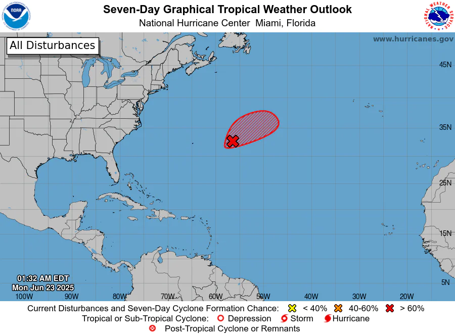
Seven-Day Graphical Tropical Weather Outlook showing a disturbance east of Bermuda with a >60% formation chance. Credit: NHC.
MIAMI, Florida – NOAA‘s National Hurricane Center in Miami, Florida, issued a Tropical Weather Outlook at 2:00 AM Eastern Daylight Time on Monday, June 23, 2025, due to the presence of Invest 90L that may form into a tropical cyclone within the next 7 days over the central Atlantic.
If this system develops into a tropical storm or hurricane, the next name on the 2025 Atlantic Hurricane List is Andrea.
Invest 90L (marked with a red shaded area) is an area of low pressure located about 500 miles east of Bermuda.
NHC forecasters say that recent satellite-derived wind data indicates the system has a well-defined surface circulation with maximum sustained winds of 30-35 mph.
Showers and thunderstorms continue to show signs of organization, and while environmental conditions are only marginally favorable, a small increase in organization and persistence of the current shower and thunderstorm activity is likely to result in the formation of a short-lived tropical depression or storm, possibly as soon as later today.
By Tuesday, this system is expected to encounter less favorable environmental conditions, ending its opportunity for further development.
Regardless of development, the system is forecast to move northeastward at 5 to 10 mph, remaining over the open central Atlantic.
This system has a 70% chance of tropical cyclone formation within the next 7 days and a 70% chance within the next 48 hours.
Computer models, often referred to as spaghetti models, show Invest 90L moving to the northeast over the open central Atlantic during the next few days.
Both the GFS (American model) and ECMWF (European model) are in general agreement with this track for the first 72 hours.
NOAA forecasts an “above-normal” 2025 Atlantic Hurricane Season, which runs from June 1 through November 30.
Although peak hurricane season isn’t until September 10, hurricane and tropical storm activity begins to pick up in late June, according to NOAA and the National Weather Service‘s historical hurricane activity data.
Copyright 2023-2025 FloridaWord.com


