National Weather Service Rain Chances for Florida Florida on Friday, July 3, 2026
TAMPA BAY, Florida – The National Weather Service Tampa Bay forecasts scattered to numerous showers and thunderstorms across the Tampa Bay region and Southwest Florida today, Friday, July 3, 2026.
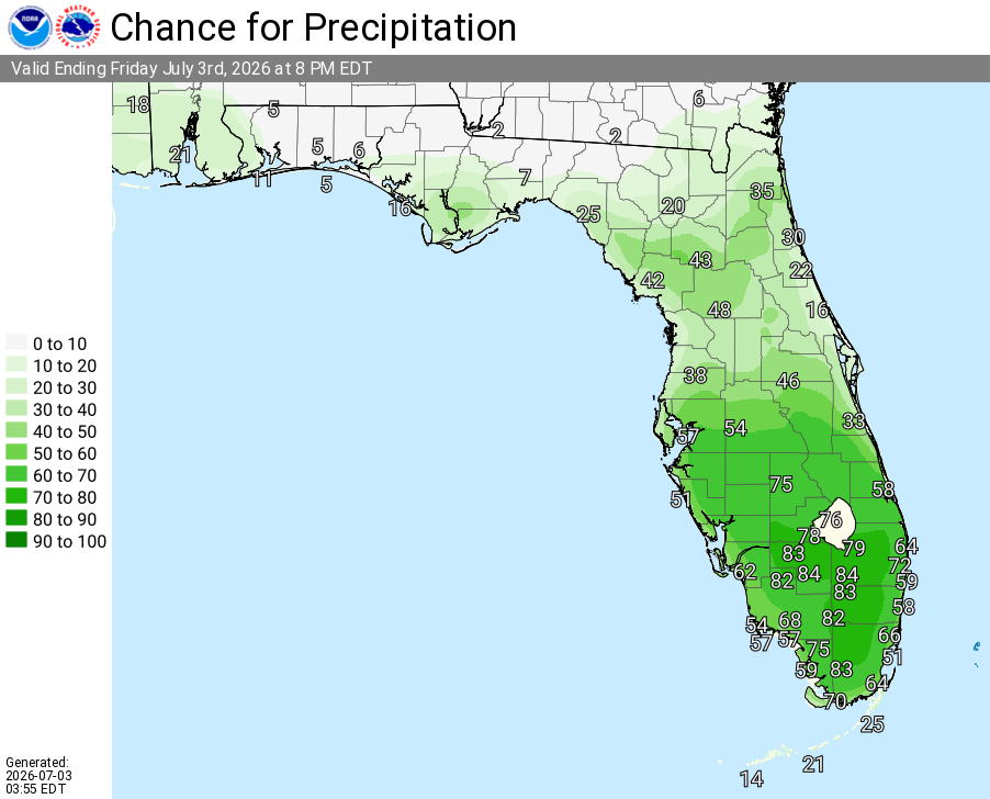
A light easterly flow combined with daytime heating and the sea breeze will trigger scattered to numerous mainly afternoon and evening thunderstorms, with the best chance of rain south of the I-4 corridor.
Storms are expected mainly this afternoon and evening. Stronger storms could produce gusty winds, small hail, and locally heavy rainfall that may cause flooding in urban, low-lying, and poor-drainage areas. Activity will diminish overnight, leaving partly to mostly cloudy skies.
High temperatures today will range from the low-to-mid 90s across the region (Tampa area around 93–94°F, up to 95–96°F near Chiefland). Heat index values are expected between 100° and 107°F.
Rain chances are lowest in the Nature Coast (around 30–40%) and increase southward, reaching 50% in the Tampa/Lakeland area, 60–70% near Sarasota and Fort Myers, and up to 80% near Arcadia/Sebring.
Scattered showers and thunderstorms, mainly after 2–3pm. Mostly sunny, with a high near 94°F. Heat index values as high as 103–104°F. Light and variable wind becoming east or southeast around 5–6 mph in the afternoon. Chance of precipitation 50–60%.
Scattered showers and thunderstorms, mainly before 10–11pm. Partly cloudy, with a low around 77–78°F. Light and variable wind. Chance of precipitation 30–40%.
Showers likely and possibly a thunderstorm. Mostly sunny, with a high near 93°F. Calm wind becoming west southwest 5 to 7 mph in the afternoon. Chance of precipitation 60–70%.
Scattered showers and thunderstorms. Partly cloudy, with a low around 78–79°F. Light and variable wind. Chance of precipitation 30%.
Showers likely and possibly a thunderstorm. Mostly sunny, with a high near 93°F. Calm wind becoming south southwest 5 to 7 mph. Chance of precipitation 50–60%.
A 20 percent chance of showers and thunderstorms. Mostly cloudy, with a low around 79°F. Southwest wind around 5 mph becoming light and variable in the evening.
Showers and thunderstorms likely, mainly after 2pm. Mostly sunny, with a high near 93°F. Southeast wind around 6 mph becoming southwest in the afternoon. Chance of precipitation 50–60%.
Showers and thunderstorms likely, mainly before 8pm. Partly cloudy, with a low around 79°F. Chance of precipitation 50–60%.
A 40–50 percent chance of showers and thunderstorms. Mostly sunny, with a high near 93–94°F.
A 30 percent chance of showers and thunderstorms. Partly cloudy, with a low around 79–80°F.
Copyright 2023-2025 FloridaWord.com


