National Weather Service Rain Chances for Florida Florida on Monday, July 6, 2026
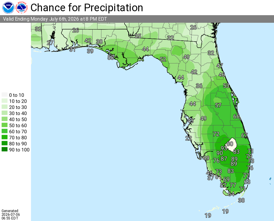
MIAMI, Florida – The National Weather Service in Miami forecasts scattered to numerous showers and thunderstorms developing this afternoon and evening across South Florida on Monday, July 6, 2026, with the highest chances focused over the interior and northern/central regions.
Storms are expected to develop through the afternoon and early evening. The strongest cells may produce gusty winds, heavy downpours, and localized flooding in poor drainage areas, particularly across the interior and central South Florida and near Lake Okeechobee. Frequent lightning will be the primary hazard.
Today’s Rain Chances
Today’s South Florida Rain Chances – Valid Monday, July 6, 2026
Major HeatRisk continues today — High temperatures will rise into the upper 88s to low 90s across most of South Florida. Peak Heat Index Values will range from 102°F to 108°F+, with the highest readings near 108°F in Miami, West Palm Beach, and Naples, and 106–107°F across much of the interior and western suburbs.
A Heat Advisory remains in effect for portions of Miami-Dade, Broward, and Palm Beach Counties.
Maximum Heat Index – Monday Afternoon, July 6, 2026
A chance of showers and thunderstorms before 4pm, then a chance of showers and thunderstorms after 5pm. Increasing clouds, with a high near 89. Heat index values as high as 105. Southeast wind 5 to 10 mph. Chance of precipitation is 30%.
Tonight
Showers and thunderstorms likely, mainly before 8pm. Partly cloudy, with a low around 83. South wind 6 to 8 mph. Chance of precipitation is 60%.
Tuesday
A 40 percent chance of showers and thunderstorms after 2pm. Mostly sunny, with a high near 90. Light south wind becoming southeast 5 to 10 mph.
Tuesday Night
A 30 percent chance of showers and thunderstorms before 8pm. Partly cloudy, with a low around 84. Southeast wind 6 to 8 mph.
Wednesday
A 20 percent chance of showers and thunderstorms after 2pm. Mostly sunny, with a high near 90. Southeast wind 5 to 11 mph.
Wednesday Night
A 10 percent chance of showers and thunderstorms before 8pm. Partly cloudy, with a low around 83. Southeast wind 7 to 9 mph.
Thursday
Sunny, with a high near 92. Southeast wind 7 to 11 mph.
Thursday Night
Mostly clear, with a low around 83.
Friday
A 30 percent chance of showers and thunderstorms. Mostly sunny, with a high near 92.
Friday Night
A 30 percent chance of showers and thunderstorms. Partly cloudy, with a low around 83.