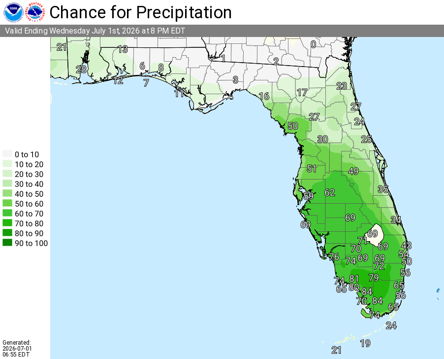
Orange County

Thunderstorms, Heavy Rain For Central Florida

Published by
FLORIDA WORD

, Florida – The National Weather Service in Melbourne forecasts isolated showers early this morning increasing in coverage to scattered showers and thunderstorms across East today, with the highest coverage anticipated across the far interior this afternoon. Highs will reach the upper 80s to low 90s°F this afternoon.

Isolated showers early along the coast will increase in coverage across the interior as the east coast sea breeze develops and moves inland this afternoon. Storms may produce frequent lightning, gusty winds up to 45 mph, and heavy downpours. Highest storm chances are expected across the far interior.

National Service Melbourne – Today’s Weather Outlook (July 1, 2026)

The main hazards during peak storm hours this afternoon include:

  • Frequent lightning
  • Gusty winds up to 45 mph
  • Heavy downpours (isolated higher amounts possible) leading to minor flooding in poor drainage areas

Exercise caution at Atlantic beaches due to a moderate rip current risk. Swim near lifeguards and never enter the surf alone. Stay hydrated and take breaks in the shade or air conditioning as typical summer heat builds this afternoon.

East Central Florida cities forecast to see warm temperatures today include:

  • Orlando (high near 90°F, 50% chance of rain/storms)
  • Daytona Beach (high near 88°F, 30% chance of rain/storms)
  • Melbourne (high near 88–91°F, ~40% chance of rain/storms)
  • Vero Beach (high near 89°F, 40% chance of rain/storms)


Melbourne Central Florida Radar

Orlando Weather Forecast

Today (Wed, Jul 1)
A slight chance of showers, then a chance of showers and thunderstorms after 11am. Mostly sunny, with a high near 90. Northeast wind 5–10 mph. Chance of precipitation is 50%. New rainfall amounts less than a tenth of an inch, except higher amounts possible in thunderstorms.
Tonight
Mostly clear, with a low around 76. Northeast wind around 5 mph.
Thursday
Showers and thunderstorms likely after 2pm. Increasing clouds, with a high near 92. East wind around 5 mph. Chance of precipitation is 60%.
Thursday Night
Showers and thunderstorms likely before 8pm. Partly cloudy, with a low around 76. East wind around 5 mph becoming calm after midnight. Chance of precipitation is 60%.
Friday
A slight chance of showers, then showers and thunderstorms after 11am. High near 92. Calm wind becoming south around 5 mph in the afternoon. Chance of precipitation is 90%.
Friday Night
Showers and thunderstorms, mainly before 8pm. Low around 77. South southeast wind around 5 mph. Chance of precipitation is 80%.
(Sat, Jul 4)
Showers and thunderstorms, mainly after 2pm. Some of the storms could produce heavy rainfall. High near 91. Calm wind becoming south southwest around 5 mph in the afternoon. Chance of precipitation is 80%.
Saturday Night
Showers and thunderstorms, mainly before 8pm. Some of the storms could produce heavy rainfall. Low around 76. South wind around 5 mph. Chance of precipitation is 80%.
Published by
FLORIDA WORD

Contact Us    Privacy Policy

Copyright 2023-2025 FloridaWord.com