Strong Thunderstorms, Heavy Rain For Tampa Bay, Southwest Florida
Published by
FLORIDA WORD
July 7, 2026 7:33 am
Share
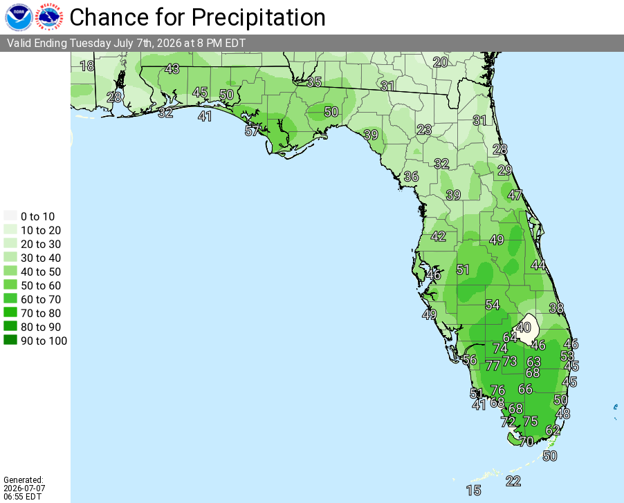
National Weather Service Rain Chances for Florida Florida on Tuesday, July 7, 2026
TAMPA BAY, Florida – The National Weather ServiceTampa Bay forecasts scattered to numerous showers and thunderstorms across the Tampa Bay region and Southwest Florida today, Tuesday, July 7, 2026.
National Weather Service Tampa Bay Radar Loop for West Central and Southwest Florida
A light easterly flow combined with daytime heating and the sea breeze will trigger scattered to numerous mainly afternoon and evening thunderstorms, with the best chance of rain near the coast during the morning and across the interior in the afternoon.
National Weather Service Tampa Bay graphic showing high temperatures and rain chances for West Central and Southwest Florida. Issued July 7, 2026.
Scattered to numerous showers and thunderstorms with locally heavy rainfall possible. Stronger storms could produce gusty winds, small hail, and locally heavy rainfall that may cause flooding in urban, low-lying, and poor-drainage areas. Activity will diminish overnight, leaving partly to mostly cloudy skies.
High temperatures today will range from the low-to-mid 90s across the region (Tampa area around 94°F, with readings up to 94°F near Chiefland and Arcadia). Heat index values are expected between 100° and 106°F.
Rain chances are lowest in the Nature Coast (around 40% near Chiefland, Crystal River, and Brooksville), 50% across the Tampa Bay area, Lakeland, Sebring, Sarasota, and Fort Myers, and highest at 60% near Arcadia.
Tampa Weather Forecast
Today (Tuesday)
Scattered showers and thunderstorms, mainly between 9am and 5pm. Mostly sunny, with a high near 94. Heat index values as high as 104–106. Calm wind becoming south southwest 5 to 8 mph in the morning. Chance of precipitation is 50%. New rainfall amounts of less than a tenth of an inch, except higher amounts possible in thunderstorms.
Tonight
Isolated showers and thunderstorms before 8pm, then isolated showers and thunderstorms after 3am. Partly cloudy, with a low around 79–80. Southwest wind around 6 mph becoming calm in the evening. Chance of precipitation is 20%.
Wednesday
Scattered showers and thunderstorms, mainly after 10am. Mostly sunny, with a high near 94. Heat index values as high as 104. South wind 3 to 8 mph. Chance of precipitation is 40%.
Wednesday Night
Partly cloudy, with a low around 80. West southwest wind around 6 mph becoming calm in the evening.
Thursday
Scattered showers and thunderstorms, mainly after 2pm. Mostly sunny, with a high near 94. Calm wind becoming west southwest 5 to 8 mph in the morning. Chance of precipitation is 30%.
Thursday Night
Scattered showers and thunderstorms before 8pm. Partly cloudy, with a low around 80. West wind around 6 mph becoming calm in the evening. Chance of precipitation is 30%.
Friday
Isolated showers and thunderstorms after 2pm. Sunny and hot, with a high near 95. Calm wind becoming west southwest 5 to 8 mph in the afternoon. Chance of precipitation is 20%.
Friday Night
Isolated showers and thunderstorms before 8pm. Partly cloudy, with a low around 80. West wind around 6 mph becoming calm in the evening. Chance of precipitation is 10%.
Saturday
A 20 percent chance of showers and thunderstorms after 2pm. Sunny, with a high near 94. Calm wind becoming southwest 5 to 7 mph in the afternoon.