North Florida

Severe Thunderstorm Risk For Florida Panhandle and Big Bend

Published by
FLORIDA WORD

, Florida – A Heat Advisory is in effect this afternoon for the Florida , western Big Bend, southeast Alabama’s Wiregrass region, and southwest Georgia, according to the National Weather Service in Tallahassee. High temperatures will reach the mid to upper 90s°F with heat indices of 108-111°F (locally higher in spots).

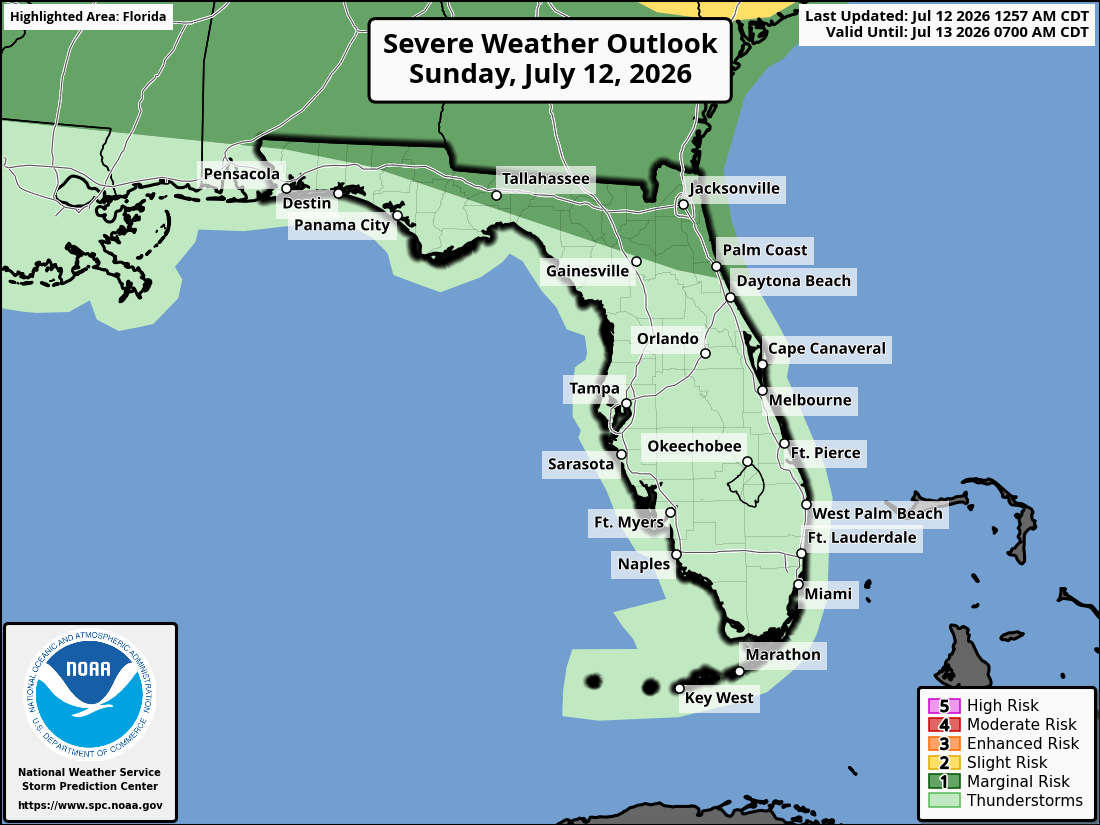
The Storm Prediction Center has issued a Marginal Risk (Level 1 of 5) of severe thunderstorms across the region today. A Marginal Risk means isolated severe storms are possible, though coverage and intensity are expected to remain limited.

National Service Tallahassee Severe Storm Risk Outlook – July 12, 2026

Scattered to widespread showers and thunderstorms are expected this afternoon into early evening, especially across the Florida Panhandle, Big Bend, southeast Alabama, and southwest Georgia. Some storms may be strong to severe.

Primary hazards with any stronger storms include strong to damaging wind gusts of 40-60 mph, frequent lightning, and locally heavy downpours. Hail is possible in the strongest cells. Lightning remains a concern with all thunderstorms.

On a positive note, beneficial rainfall is expected with any storms today, helping to ease ongoing dry conditions. Additional rain chances increase into Monday across the broader region.

Tallahassee Radar Loop

Areas at risk for thunderstorms and possible strong to severe weather today include:

  • Marianna
  • Perry
  • Tallahassee

High temperatures across the Florida Panhandle and will be in the mid to upper 90s °F (heat index 108-111°F+ in Heat Advisory areas). Overnight lows will drop into the mid to upper 70s.

TALLAHASSEE WEATHER FORECAST

Today
Showers and thunderstorms likely, mainly between 2pm and 4pm. Mostly sunny, with a high near 92. Heat index values as high as 105. Light west wind becoming southwest 5 to 10 mph in the afternoon. Chance of precipitation is 60%. New rainfall amounts of less than a tenth of an inch, except higher amounts possible in thunderstorms.
Tonight
A chance of showers and thunderstorms before 4am, then a slight chance of showers between 4am and 5am. Partly cloudy, with a low around 75. South southwest wind around 5 mph becoming calm after midnight. Chance of precipitation is 30%.
Monday
Showers and thunderstorms. High near 87. Light southwest wind becoming west southwest 5 to 10 mph in the morning. Winds could gust as high as 20 mph. Chance of precipitation is 80%. New rainfall amounts between a tenth and quarter of an inch, except higher amounts possible in thunderstorms.
Monday Night
Showers and thunderstorms likely before 11pm, then a chance of showers. Mostly cloudy, with a low around 73. West wind around 5 mph becoming calm in the evening. Chance of precipitation is 60%.
Tuesday
A chance of showers, then showers and thunderstorms likely after 11am. Partly sunny, with a high near 88. Light west southwest wind increasing to 5 to 10 mph in the morning. Winds could gust as high as 20 mph. Chance of precipitation is 70%.
Tuesday Night
Showers and thunderstorms likely before 8pm. Partly cloudy, with a low around 73. Chance of precipitation is 60%.
Wednesday
A 30 percent chance of showers and thunderstorms, mainly after 2pm. Mostly sunny, with a high near 92.
Wednesday Night
A 30 percent chance of showers and thunderstorms before 8pm. Partly cloudy, with a low around 75.
Thursday
A 20 percent chance of showers and thunderstorms after 2pm. Sunny, with a high near 93.
Thursday Night
A 10 percent chance of showers and thunderstorms before 8pm. Mostly clear, with a low around 76.
Friday
A 40 percent chance of showers and thunderstorms. Sunny, with a high near 94.
Friday Night
A 30 percent chance of showers and thunderstorms. Mostly clear, with a low around 76.
Published by
FLORIDA WORD

Contact Us    Privacy Policy

Copyright 2023-2025 FloridaWord.com