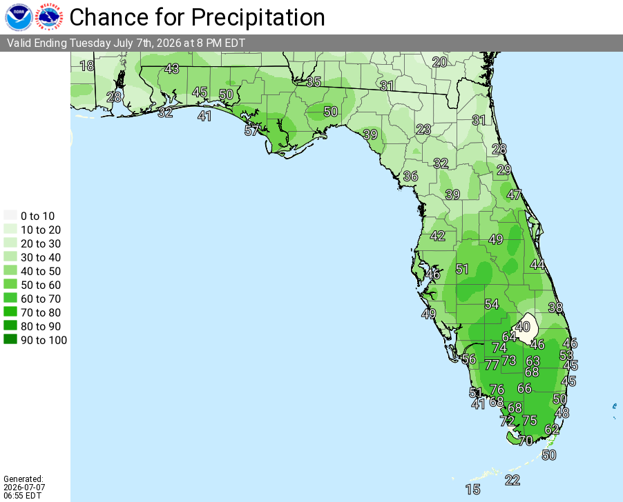
National Weather Service Rain Chances for Florida Florida on Tuesday, July 7, 2026
TALLAHASSEE, Florida – The National Weather Service is highlighting a typical summer weather pattern today (Tuesday, July 7, 2026) across southeast Alabama’s Wiregrass region, southwest Georgia, and the Florida Panhandle, with hot days, scattered afternoon thunderstorms, and warm nights expected through the weekend and into early next week.
The National Weather Service Tallahassee reports another typical summer day today with scattered afternoon storms and highs near 93°F. Gusty winds and locally heavy rain are possible in the stronger storms. The NWS may issue a Heat Advisory for Wednesday.
Showers and thunderstorms can be expected today, especially this afternoon. While most areas will see rain, the heaviest storms may produce locally heavy rainfall and isolated flash flooding.
The main hazards with thunderstorms today are frequent dangerous lightning, heavy rainfall capable of producing flash flooding, and a few gusty winds.
Heat and humidity will remain a concern through the period. High temperatures are forecast to reach the mid-90s with heat index values frequently in the 105–110°F+ range across the region. This level of heat affects anyone without proper cooling or hydration. Stay hydrated, limit strenuous outdoor activity during the heat of the day, and check on elderly residents, children, and pets.
Cities at risk for thunderstorms, locally heavy rain, possible localized flooding, and dangerous heat include:
Tuesday (Jul 7)
Scattered showers and thunderstorms, mainly in the afternoon. High near 93°F. Heat index values up to around 105°F. Southwest wind 5–10 mph. Chance of precipitation 40–60%. Locally higher rainfall amounts possible in stronger storms.
Tuesday Night
A 20% chance of showers and thunderstorms early, then clearing. Low around 76°F.
Wednesday (Jul 8)
Mostly sunny and hot. A 30% chance of afternoon showers and thunderstorms. High near 95°F. Heat index values up to 107°F or higher. Possible Heat Advisory.
Thursday – Saturday
Mostly sunny and hot. Lower rain chances (20–30%). Highs in the mid-90s. Heat index values in the 105°F+ range at times.
Sunday & Early Next Week
Mostly sunny and hot with increasing afternoon storm chances later in the period. Highs in the mid-90s with dangerous heat index values continuing. Typical summer pattern persists.
Copyright 2023-2025 FloridaWord.com