National Weather Service Rain Chances for Florida Florida on Monday, June 29, 2026.
TAMPA BAY, Florida – The National Weather Service Tampa Bay is forecasting scattered showers and thunderstorms for the Nature Coast and West Central Florida today, Monday, June 29, 2026, as hot and humid conditions continue.
Hot and humid conditions will continue today with daytime highs in the mid to upper 90s, reaching 97°F in parts of the Nature Coast (such as Chiefland). Heat index values will reach 100–107°F (locally up to 110°F across the Nature Coast). A Heat Advisory is in effect for the Nature Coast through this evening.
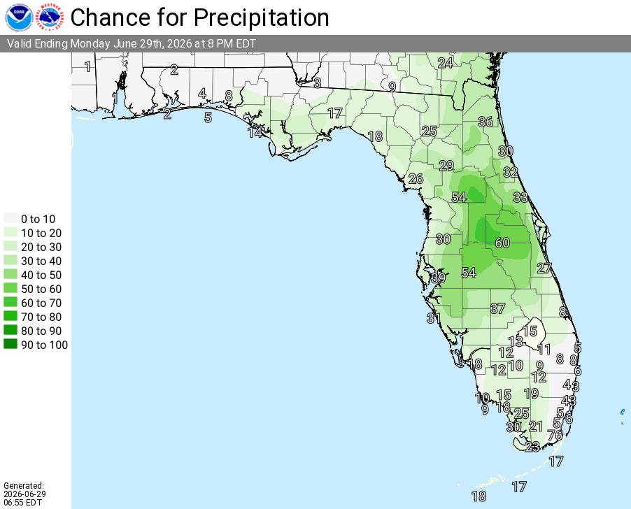
Scattered showers and isolated thunderstorms are expected to develop this afternoon and continue into the evening. Rain chances today range from 20–30% across the northern Nature Coast (Chiefland, Crystal River, Brooksville) to 30–50% across West Central and Southwest Florida, with the highest chances (around 50%) near Lakeland.
The primary hazards include lightning, gusty winds, and locally heavy rainfall. Isolated stronger storms could produce damaging wind gusts capable of downing tree limbs and causing brief power outages.
The risk area includes the Nature Coast (Chiefland, Crystal River, Brooksville) through West Central Florida, including Tampa, Lakeland, Sarasota, Sebring, Arcadia, and Fort Myers. Thunderstorms will be driven by daytime heating and sea breeze interactions. Activity is expected to diminish after sunset.
A Marginal Risk (Level 1 of 4) of excessive rainfall is in effect for most of West Central and Southwest Florida on Tuesday afternoon and evening. Localized rainfall totals of 2 to 4 inches are possible, with the potential for ponding of water in urban, low-lying, and poor drainage areas.
| Period | Forecast |
|---|---|
| Today (Monday, June 29) | Scattered showers and thunderstorms after 2pm. Mostly sunny and hot, with a high near 96°F. Heat index values as high as 105°F. Calm wind becoming west northwest around 6 mph in the afternoon. Chance of precipitation is 40%. |
| Tonight | Scattered showers and thunderstorms, mainly before 8pm. Partly cloudy, with a low around 78–79°F. North northwest wind around 5 mph becoming calm in the evening. Chance of precipitation is 30%. |
| Tuesday (June 30) | Showers likely and possibly a thunderstorm after 2pm. Mostly sunny and hot, with a high near 95°F. Chance of precipitation is 70%. New rainfall amounts of less than a tenth of an inch, except higher amounts possible in thunderstorms. |
| Tuesday Night | Showers likely and possibly a thunderstorm before 8pm, then scattered showers and thunderstorms between 8pm and 2am. Partly cloudy, with a low around 78°F. Chance of precipitation is 60%. |
| Wednesday (July 1) | Showers likely and possibly a thunderstorm after 2pm. Mostly sunny and hot, with a high near 93–95°F. Chance of precipitation is 70%. |
| Wednesday Night | Showers likely and possibly a thunderstorm before 8pm, then scattered showers and thunderstorms. Partly cloudy, with a low around 78°F. Chance of precipitation is 60%. |
| Thursday (July 2) | Showers likely and possibly a thunderstorm. Sunny, with a high near 93°F. Chance of precipitation is 60%. |
| Thursday Night | Showers and thunderstorms likely. Partly cloudy, with a low around 79°F. Chance of precipitation is 60%. |
| Friday (July 3) | Scattered showers and thunderstorms. Sunny, with a high near 94°F. Chance of precipitation is 50%. |
Copyright 2023-2025 FloridaWord.com


