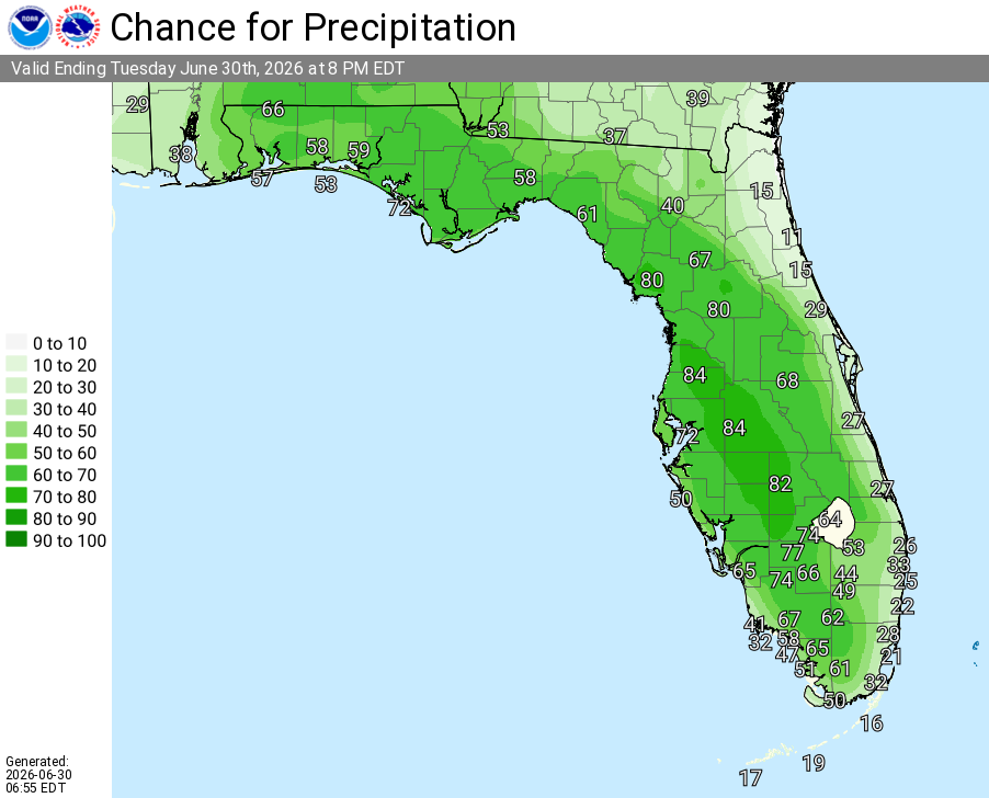
Orange County

Thunderstorms, Heavy Rain, Hail For Central Florida

Published by
FLORIDA WORD

, Florida – The National Weather Service in Melbourne forecasts scattered to numerous showers and thunderstorms across East today, with the highest coverage anticipated inland near the I-4 corridor this afternoon and evening. Heat indices will reach 100–107°F (locally higher) this afternoon, with a Heat Advisory in effect for northern portions of the area.

Scattered to locally numerous showers and thunderstorms will develop inland this afternoon and shift eastward toward the coast and offshore through the afternoon and evening. Storms may produce frequent lightning, gusty to locally damaging winds, isolated heavy rainfall, and small hail. A Marginal Risk (Level 1 of 5) for severe exists mainly across inland areas from 3–9 PM.

Melbourne – Today’s Weather Outlook (June 30, 2026)

The main hazards during peak storm hours this afternoon and evening include:

  • Frequent to excessive lightning
  • Locally heavy rainfall (¼–½ inch, with isolated higher amounts possible) leading to minor flooding in poor drainage areas
  • Wind gusts of 45–60 mph (isolated stronger/damaging gusts possible)
  • Small hail in stronger storms

Exercise caution at Atlantic beaches due to a moderate rip current risk. Swim near lifeguards and never enter the surf alone. Stay cool and hydrated as heat indices reach 100–107°F+ this afternoon. A Moderate to Major HeatRisk is forecast — practice heat safety: stay hydrated, take frequent breaks in air conditioning or shade, and never leave children or pets in vehicles.

East Central Florida cities forecast to see warm temperatures today include:

  • Orlando (high near 92°F, 70% chance of rain/storms)
  • Daytona Beach (high near 90–92°F, 30% chance of rain/storms)
  • Melbourne (high near 90–91°F, 30% chance of rain/storms)
  • Vero Beach (high near 91°F, 20–40% chance of rain/storms)


National Weather Service Melbourne Central Florida Radar

Orlando Weather Forecast

Today (Tue, Jun 30)
Showers and thunderstorms likely, mainly between 2pm and 4pm. Mostly sunny, with a high near 92. Heat index values as high as 105–107°F. Light and variable wind becoming northeast 5–10 mph in the afternoon. Chance of precipitation is 70%. New rainfall amounts between a quarter and half an inch possible in storms.
Tonight
A 30 percent chance of showers and thunderstorms, mainly before 7pm. Partly cloudy, with a low around 77. Northeast wind around 5 mph.
Wednesday
A 50 percent chance of showers and thunderstorms, mainly between 2pm and 5pm. Mostly sunny, with a high near 91. Northeast wind 5–10 mph.
Wednesday Night
Mostly clear, with a low around 75. East northeast wind 5–10 mph.
Thursday
Showers and thunderstorms likely after 2pm. Mostly sunny, with a high near 92. East northeast wind around 5 mph. Chance of precipitation is 60%.
Thursday Night
Showers and thunderstorms likely before 8pm. Partly cloudy, with a low around 77. East wind 5–10 mph becoming light east southeast after midnight. Chance of precipitation is 60%.
Friday
Showers and thunderstorms likely, mainly after 2pm. Mostly sunny, with a high near 92. Calm wind becoming south southeast around 5 mph in the afternoon. Chance of precipitation is 70%.
Friday Night
Showers and thunderstorms likely, mainly before 8pm. Partly cloudy, with a low around 77. Southeast wind around 5 mph. Chance of precipitation is 60%.
(Sat, Jul 4)
Showers and thunderstorms, mainly after 2pm. High near 92. South southwest wind around 5 mph. Chance of precipitation is 80%.
Saturday Night
Showers and thunderstorms, mainly before 8pm. Low around 77. South wind around 5 mph. Chance of precipitation is 80%.
Published by
FLORIDA WORD

Contact Us    Privacy Policy

Copyright 2023-2025 FloridaWord.com