Thunderstorms, Heavy Rain For Tampa Bay, Southwest Florida
Published by
FLORIDA WORD
June 30, 2026 8:47 am
Share
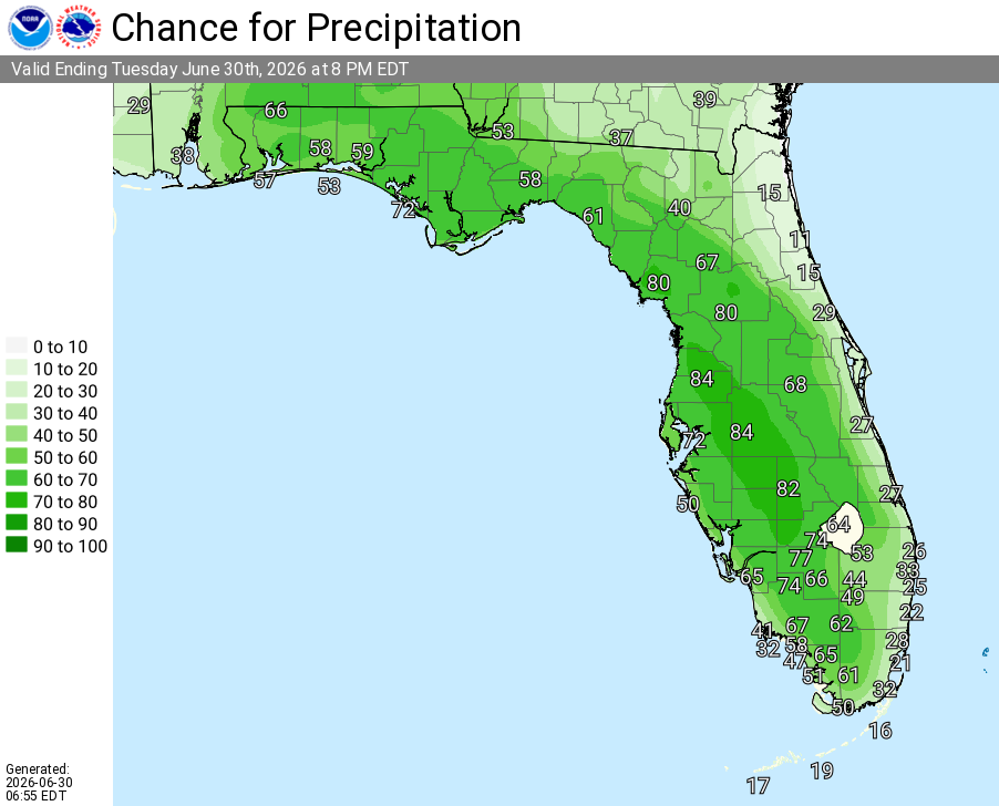
National Weather Service Rain Chances for Florida Florida on Tuesday, June 30, 2026.
TAMPA BAY, Florida – The National Weather Service Tampa Bay forecasts numerous showers and thunderstorms across the Tampa Bay region and Southwest Florida today, Tuesday, June 30, 2026. A weakening frontal boundary moving south will combine with deep moisture, the sea breeze, and daytime heating to produce scattered to numerous showers and thunderstorms, with locally heavy rainfall possible.
Storms are expected mainly this afternoon and evening. Activity will diminish overnight, leaving partly to mostly cloudy skies.
The National Weather Service (NWS) Tampa Bay has issued a weather outlook for Tuesday, June 30, 2026, calling for numerous showers and thunderstorms across the Tampa Bay region and west Central Florida.
The potential hazards include lightning, heavy rainfall, and localized flooding of urban, low-lying, and poor drainage areas. Heat index values may reach 100–107°F or higher in spots.
The forecast covers areas such as Tampa, St. Petersburg, Sarasota, and northward toward the Nature Coast. Highest rain chances are expected this afternoon and evening.
Showers and thunderstorms will be most numerous during the afternoon and early evening hours before diminishing overnight.
National Weather Service Tampa Radar for West Central Florida and Southwest Florida.
Tampa Weather Forecast
Today (Tue, Jun 30)
Showers and thunderstorms likely, mainly after 2pm. Partly sunny and hot, with a high near 95. Heat index values as high as 107. Chance of precipitation is 70%. Calm wind becoming west northwest 5 to 7 mph in the afternoon.
Tonight (Tue, Jun 30)
Showers and thunderstorms likely, mainly before 9pm. Mostly cloudy, with a low around 76. Northeast wind around 5 mph becoming calm.
Wednesday (Jul 1)
Scattered showers and thunderstorms, mainly after 3pm. Mostly sunny, with a high near 94. Heat index values as high as 103. East northeast wind 5 to 7 mph. Chance of precipitation is 30%.
Wednesday Night (Jul 1)
Scattered showers and thunderstorms, mainly before 8pm. Partly cloudy, with a low around 76. East northeast wind 3 to 6 mph. Chance of precipitation is 30%.
Thursday (Jul 2)
Scattered showers and thunderstorms after 2pm. Mostly sunny, with a high near 94. East northeast wind 3 to 5 mph. Chance of precipitation is 50%.
Thursday Night (Jul 2)
Scattered showers and thunderstorms before 2am. Partly cloudy, with a low around 78. North wind around 5 mph becoming calm.
Friday (Jul 3)
Showers and thunderstorms likely, mainly after 2pm. Mostly sunny, with a high near 93. Calm wind becoming southwest 5 to 7 mph in the afternoon. Chance of precipitation is 70%.
Friday Night (Jul 3)
Showers and thunderstorms likely, mainly before 8pm. Mostly cloudy, with a low around 78. Light and variable wind. Chance of precipitation is 60%.
Saturday (Jul 4)
Showers and thunderstorms likely, mainly after 2pm. Mostly sunny, with a high near 93. Calm wind becoming west southwest 5 to 7 mph in the afternoon. Chance of precipitation is 70%.
Saturday Night (Jul 4)
A chance of showers and thunderstorms before midnight. Partly cloudy, with a low around 78. West wind around 5 to 7 mph becoming light and variable.