National Weather Service Rain Chances for Florida Florida on Monday, June 15, 2026.
TALLAHASSEE, Florida – Much cooler conditions are in place today with widespread showers and thunderstorms expected this afternoon and evening, according to the National Weather Service in Tallahassee.
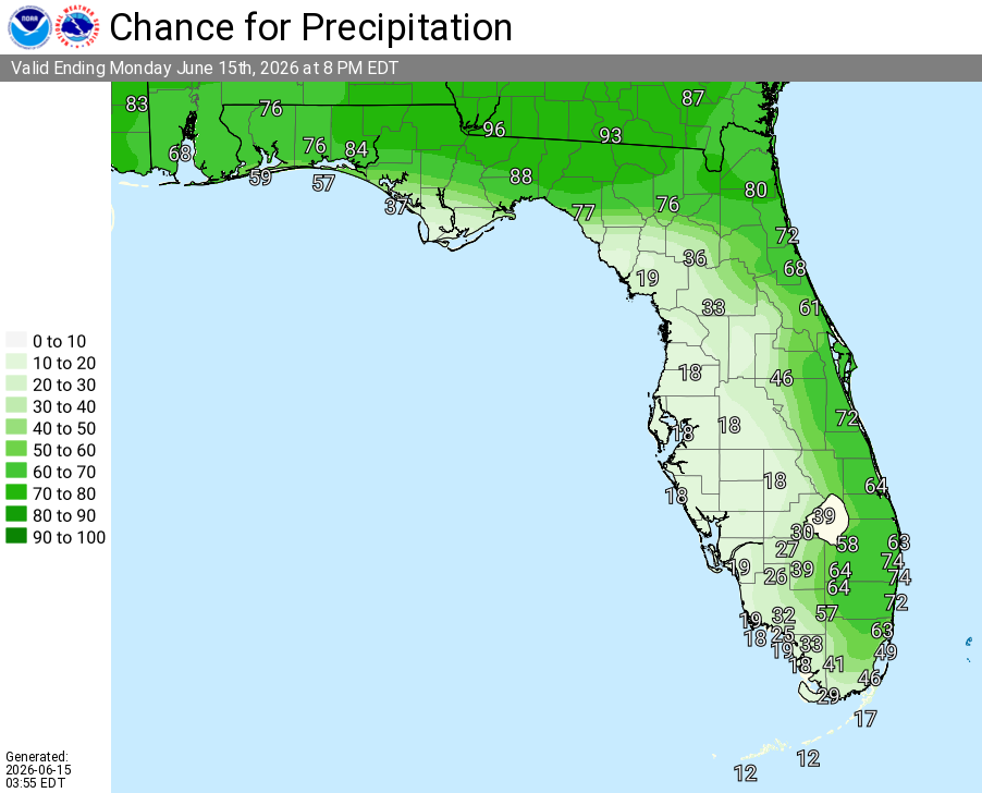
Stronger moisture return combined with daytime heating will fuel scattered to widespread showers and thunderstorms across the Tri-State region (North Florida, Southeast Alabama, and Southwest Georgia). Activity will favor inland areas this afternoon and evening, with the highest coverage and heaviest rainfall mainly along and north of the I-10 corridor.
A few storms may become strong to locally severe, bringing the potential for damaging wind gusts and heavy rainfall. Primary hazards include locally heavy rainfall, dangerous lightning, gusty winds, and torrential downpours. Isolated flash flooding is possible where storms train or move slowly over the same areas.
Scattered showers and thunderstorms are possible across the entire Tri-State region through early evening, with the best coverage shifting inland this afternoon.
A High Rip Current Risk is in effect for Walton, Bay, and west-facing Gulf County beaches today.
Patchy fog is possible early this morning in portions of southeast Alabama, southwest Georgia, and the Florida Panhandle (mostly clearing by mid-morning).
On a positive note, beneficial rainfall is expected region-wide today and will continue through much of the week. This will help alleviate any lingering dry conditions across the area as we settle into Florida’s typical summer rainy season pattern.
Cities at risk for thunderstorms today include:
High temperatures across the Florida Panhandle and north Florida will be in the upper 80s to low 90s °F (much cooler than recent days), with the coolest readings near the coast. Overnight lows will drop into the low 70s.
Copyright 2023-2025 FloridaWord.com


