ORLANDO, Florida – The National Weather Service in Melbourne reports the active weather pattern continues across east central Florida on this warm and muggy Monday, June 15, 2026.
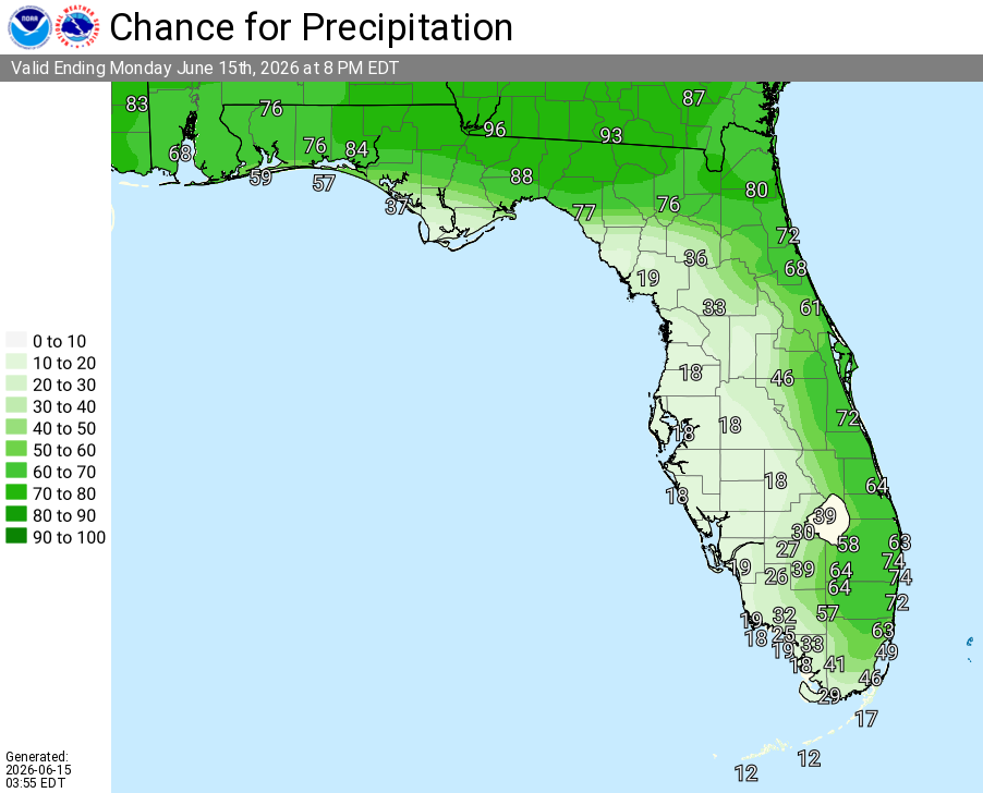
A Marginal Risk (1/4) of excessive rainfall is forecast along the east coast today, with the greatest rain chances focused along the coast late afternoon into this evening. Slow-moving storms may produce rainfall totals of 1-3 inches in some spots, exceeding 4 inches in isolated locations, along with frequent lightning and strong wind gusts.

NWS Melbourne Today’s Weather Outlook Graphic
The NWS warns of the following hazards during the peak storm hours this afternoon and evening:
- Frequent lightning strikes
- Wind gusts up to 50 mph in the strongest storms
- Locally heavy downpours that may cause localized flooding in low-lying and poor drainage areas (with some spots potentially exceeding 4 inches of rain)
A MODERATE Rip Current Risk is in effect today for ALL Atlantic beaches in Volusia, Space, and Treasure Coasts. Swim near a lifeguard and follow beach safety instructions.
East Central Florida cities forecast to see warm temperatures today include:
- Orlando (high near 94°F, rain chance 50%)
- Daytona Beach (high near 94°F, rain chance 60%)
- Melbourne (high near 94°F, rain chance 70%)
- Vero Beach (high near 94°F, rain chance 60%)
Orlando Weather Forecast
Today (Monday)
Scattered to numerous showers and thunderstorms this afternoon, with the greatest chances along the east coast. High near 94°F. Rain chance 40-60%.
Tonight
Chance of showers and thunderstorms early, then partly cloudy. Low around 76-77°F. Rain chance 20-40% before midnight.
Tuesday
Mostly sunny, with a 40-50% chance of showers and thunderstorms after 2pm. High near 92°F. West southwest wind 5 to 10 mph, with gusts as high as 20 mph.
Tuesday Night
A chance of showers and thunderstorms before 11pm, then a slight chance of showers between 11pm and 2am. Mostly cloudy, then gradually becoming mostly clear, with a low around 76-77°F. West wind 5 to 10 mph. Chance of precipitation is 30%.
Wednesday
A 40 percent chance of showers and thunderstorms after 2pm. Mostly sunny, with a high near 92°F. Southwest wind 5 to 10 mph.
Wednesday Night
A 30 percent chance of showers and thunderstorms before 8pm. Mostly cloudy, with a low around 77-78°F. West northwest wind around 5 mph becoming south in the evening.
Thursday
A 40 percent chance of showers and thunderstorms after 2pm. Partly sunny, with a high near 94°F. South wind 5 to 10 mph.
Thursday Night
A 30 percent chance of showers and thunderstorms before 2am. Mostly cloudy, with a low around 78°F. South southwest wind around 5 mph.