Thunderstorms, Flooding, Heavy Rain For North Florida
Published by
FLORIDA WORD
June 13, 2026 8:55 am
Share
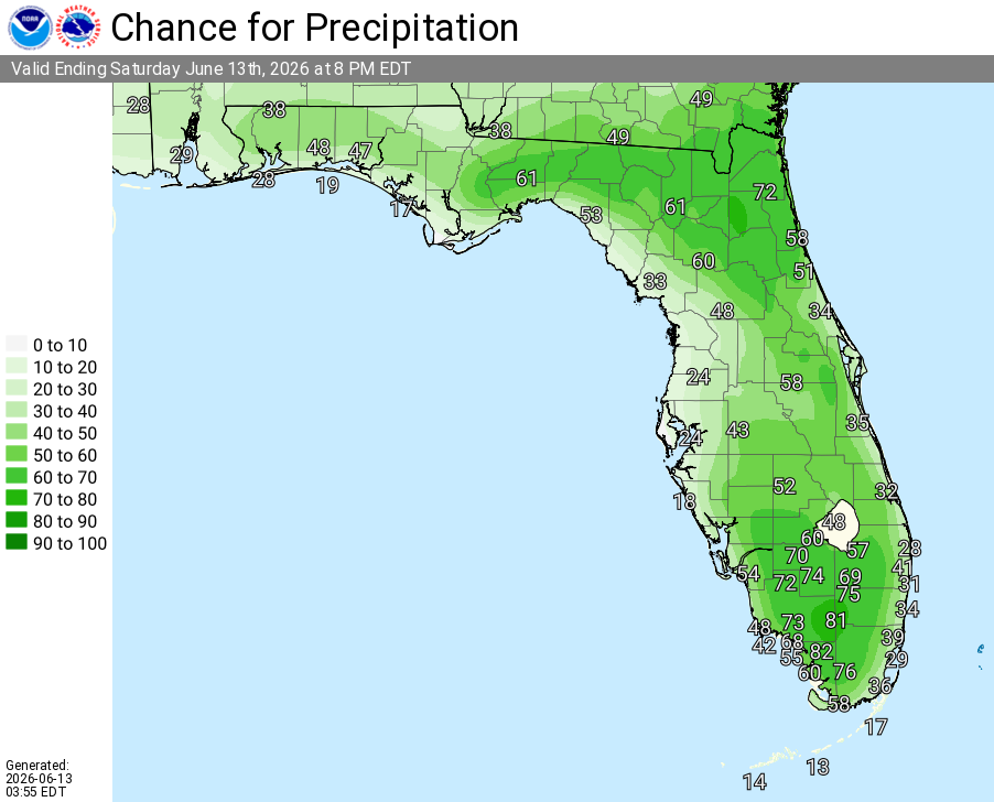
National Weather Service Rain Chances for Florida on Saturday, June 13, 2026.
JACKSONVILLE, Florida – The National Weather Service in Jacksonville is forecasting continued hot, humid, and unsettled summer-like conditions across Northeast Florida and Southeast Georgia through at least Tuesday night.
According to NWS Jacksonville, the risk of rainfall causing flash or urban flooding remains elevated today due to tropical moisture, already saturated ground from recent rains, and the potential for slow-moving or training thunderstorms.
Today (Saturday, June 13): Localized Flood Risk generally south of Waycross and likely along and west of I-95, especially this afternoon and evening. Expected rainfall 0.5–1.5 inches, with locally higher amounts of 2–4 inches possible in heavier downpours. Storms may produce rainfall rates of 3–5 inches per hour. Flooding of urban & poor drainage areas and locations already saturated from the last few days is possible.
Saturday through Tuesday night: Daily afternoon and evening downpours and strong storms likely. Additional rainfall amounts of 1–3+ inches widespread, with locally higher amounts possible in training or repeated thunderstorms. Marginal risk of excessive rainfall across much of the area.
According to NWS Jacksonville, summer-like conditions will dominate with daily afternoon and evening thunderstorms, elevated heat indices, and the potential for gusty winds in stronger storms.
Key hazards this period include:
Daily afternoon/evening thunderstorms with locally heavy rainfall (additional 1–3+ inches through Tuesday night, localized higher amounts possible in training storms) and gusts up to 40-45 mph in stronger cells
Urban, poor drainage, and low-lying area flooding possible due to saturated ground and heavy downpours — exercise caution on slick roads
Heat indices of 104°–108°F (peak heat midday through early evening) with high temperatures in the mid-90s
Lightning safety critical – seek shelter in a building or hard-topped vehicle at the first sign of thunder or lightning
NWS Jacksonville is forecasting hot and humid conditions with a high chance of showers and thunderstorms mainly in the afternoon and evening. Isolated strong storms are possible, particularly south of Waycross and in areas along or west of I-95 today.
Tropical moisture will continue to support daily thunderstorm activity. While the rain helps with wildfire suppression, long-term drought conditions persist and burn bans remain in effect for many counties.
With the ground saturated in many areas from recent heavy rain, even brief intense downpours this afternoon and evening could cause temporary urban and localized flooding. Motorists should exercise extra caution on slick roads.
Beachgoers should remain cautious of elevated surf and possible rip currents at Northeast Florida and Southeast Georgia beaches including St. Simons, Jekyll, Fernandina, Jacksonville, St. Augustine, and Flagler. Follow local beach patrol guidance.
National Weather Service Jacksonville Weather Radar for Northeast Florida
North Florida and southeast Georgia locations expecting daily thunderstorms and elevated heat this period include: Gainesville, Ocala, Lake City, Starke, Palatka, Jacksonville (inland areas), Waycross, Brunswick, and Homerville.
Jacksonville Weather Forecast
Today (Saturday)
Showers and thunderstorms likely, especially this afternoon and evening. Highs 96–97°F. Heat index values up to 104–108°F. Winds light and variable becoming east/southeast. Chance of precipitation 60–80% (highest in favored areas south of Waycross and along/west of I-95). New rainfall amounts between a half inch and 2+ inches possible in heavier thunderstorms. Localized flooding possible.
Tonight
Showers and thunderstorms likely, mainly early in the evening. Mostly cloudy, with a low around 77–79°F. Chance of precipitation 40–60%. Additional rainfall possible.
Sunday
Mostly sunny and hot with a 50% chance of showers and thunderstorms, mainly in the afternoon and evening. High near 95°F. Heat indices in the 100–105°F range possible.
Monday
Mostly sunny with showers and thunderstorms likely, mainly in the afternoon and evening. High near 94°F. Continued chance of locally heavy rainfall.