Severe Thunderstorms, Heavy Downpours For North Florida
Published by
FLORIDA WORD
June 29, 2026 3:04 pm
Share
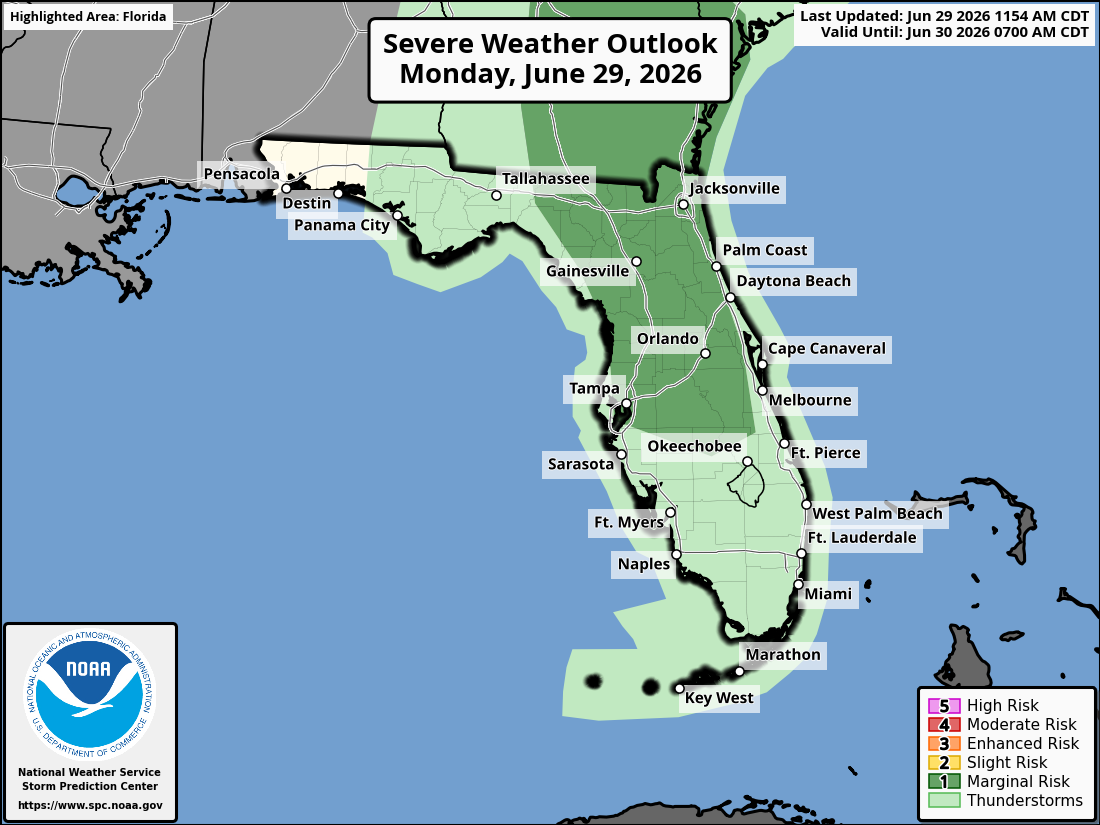
National Weather Service Storm Prediction Center Severe Weather Outlook for Florida for Monday, June 29, 2026.
JACKSONVILLE, Florida – The National Weather Service Storm Prediction Center has placed portions of southeast Georgia and northeast Florida under a Marginal Risk (level 1/5) for severe thunderstorms today, Monday, June 29, 2026.
Strong to isolated severe thunderstorms are expected across southeast Georgia and northeast Florida, mainly during the afternoon and early evening hours.
According to NWS Jacksonville, stronger storms may develop with the Marginal (1/5) risk level, with isolated strong-to-severe thunderstorms possible across the shaded area.
Stronger storms today may produce:
Damaging winds (40-60 mph) – Primary threat
Frequent lightning
Locally heavy downpours
Localized flooding (especially in urban and low-lying areas)
A 30 percent chance of showers and thunderstorms. Partly sunny and hot, with a high near 97. Heat index values as high as 105. Northwest wind around 6 mph.
Tonight
A 40 percent chance of showers and thunderstorms, mainly before 10pm. Partly cloudy, with a low around 79. Southeast wind around 6 mph becoming calm in the evening.
Tuesday
A 20 percent chance of showers and thunderstorms after 1pm. Mostly sunny, with a high near 91. Heat index values as high as 102. Breezy, with a light northeast wind becoming east 10 to 15 mph in the morning. Winds could gust as high as 18 mph.
Tuesday Night
Partly cloudy, with a low around 77. East wind 5 to 10 mph becoming light northeast after midnight.
Wednesday
A slight chance of showers and thunderstorms before 8am, then a slight chance of showers between 8am and 2pm. Mostly sunny, with a high near 90. Breezy, with a northeast wind 7 to 15 mph, with gusts as high as 21 mph. Chance of precipitation is 20%.
Wednesday Night
Mostly clear, with a low around 76.
Thursday
A 20 percent chance of showers before 2pm. Mostly sunny, with a high near 91.
Thursday Night
Mostly clear, with a low around 76.
Friday
A 30 percent chance of showers and thunderstorms after 2pm. Mostly sunny, with a high near 93.
Friday Night
A 30 percent chance of showers and thunderstorms before 8pm. Partly cloudy, with a low around 77.