Severe Thunderstorm, Tornado Risk For Florida Panhandle and Big Bend
Published by
FLORIDA WORD
June 16, 2026 8:44 am
Share
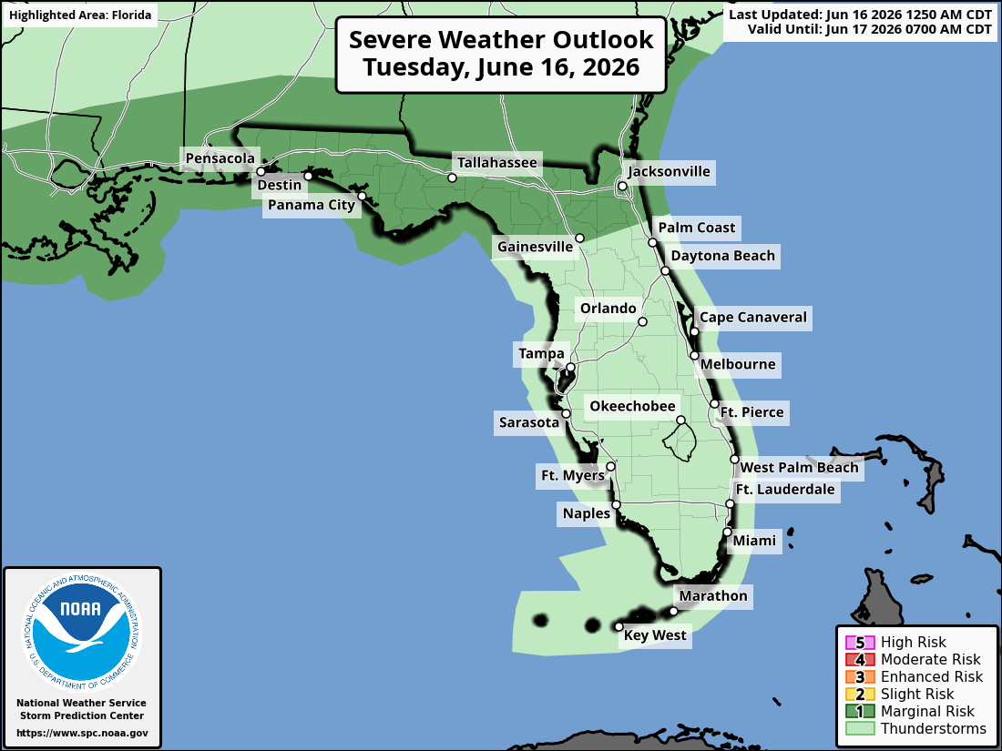
National Weather Service Storm Prediction Center Severe Weather Outlook for Florida on Tuesday, June 16, 2026.
TALLAHASSEE, Florida – The National Weather Service Storm Prediction Center has forecast a Marginal Risk (Level 1 of 5) of strong to severe thunderstorms across parts of southeast Alabama’s Wiregrass region, southwest Georgia, and the Florida Panhandle for today, June 16, 2026.
According to the National Weather Service Tallahassee, a few strong to marginally severe thunderstorms are expected today with localized pockets of damaging wind gusts impacting trees and power lines. Occasional rounds of heavy rainfall are likely, and some localized flooding could occur with the heaviest rains.
The primary hazards with any stronger storms include isolated damaging wind gusts up to 60 mph, heavy rainfall with localized flooding possible, and frequent dangerous lightning. A brief tornado or hail cannot be completely ruled out but the overall threat remains low.
Most areas can expect 2–3 inches of rainfall today, with isolated higher totals of 4–5 inches possible. There is a slight risk of excessive rainfall, which may lead to isolated flash flooding and ponding on roadways.
Showers and thunderstorms. High near 89. Light west southwest wind becoming west 5 to 10 mph in the afternoon. Chance of precipitation is 80%. New rainfall amounts between a quarter and half of an inch possible.
Tonight
Showers and thunderstorms, mainly before 9pm, then showers likely and possibly a thunderstorm after 4am. Low around 73. South southwest wind around 5 mph. Chance of precipitation is 80%. New rainfall amounts between a half and three quarters of an inch possible.
Wednesday
Showers and thunderstorms likely, mainly before 2pm. Partly sunny, with a high near 85. Southwest wind 5 to 10 mph, with gusts as high as 20 mph. Chance of precipitation is 60%. New rainfall amounts between a quarter and half of an inch possible.
Wednesday Night
Mostly cloudy, with a low around 77. South wind around 5 mph.
Thursday
Showers and thunderstorms likely, mainly after 2pm. Partly sunny, with a high near 90. South southwest wind 10 to 15 mph, with gusts as high as 25 mph. Chance of precipitation is 60%.
Thursday Night
Showers and thunderstorms likely, mainly before 8pm. Mostly cloudy, with a low around 77. Chance of precipitation is 60%.
Friday
Showers and thunderstorms likely, mainly after 2pm. Partly sunny, with a high near 90. Chance of precipitation is 60%.
Friday Night
Showers and thunderstorms likely, mainly before 8pm. Mostly cloudy, with a low around 75. Chance of precipitation is 60%.