Severe Thunderstorm, Hail, Tornado Risk For South Florida
Published by
FLORIDA WORD
June 24, 2026 2:04 pm
Share
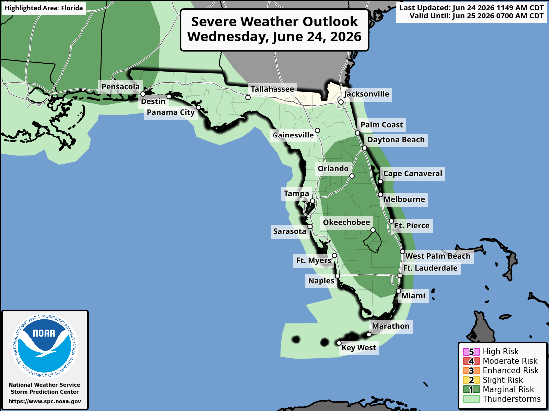
National Weather Service Storm Prediction Center Severe Weather Outlook for Florida for Wednesday, June 24, 2026.
MIAMI, Florida – The National Weather Service Storm Prediction Center has issued a marginal risk (Level 1/5) severe weather outlook for South Florida due to the potential for severe thunderstorms expected to impact the region this afternoon and evening on Wednesday, June 24, 2026.
The National Weather Service in Miami forecasts scattered to numerous showers and thunderstorms in South Florida this afternoon through early evening, with a marginal risk of severe storms primarily across the east coast of South Florida, including Miami-Dade and Broward counties (Miami, Fort Lauderdale, and Boca Raton areas). Storms could develop as early as 1–2pm but are most likely between 3pm and 9pm.
NWS Miami – Isolated Severe Thunderstorm Threat Today, June 24, 2026
Main hazards include frequent lightning, gusty to damaging winds, and locally heavy downpours that may bring poor drainage flooding. The strongest storms could produce wind gusts of 50-60 mph. An isolated tornado or hail cannot be ruled out, though these are less likely than the primary threats of wind and lightning.
NWS Miami Rain Chances, June 24, 2026
These storms may produce wind gusts up to 60 mph and locally heavy rainfall.
NWS Miami South Florida Doppler Radar
High temperatures will range from the upper 80s to low 90s this afternoon, with heat indices reaching 103°F or higher. Elevated heat risk continues through this evening.
Miami Weather Forecast
Wednesday
Mostly sunny to partly cloudy, with a chance of showers and thunderstorms, mainly after 2–3pm. High near 91–92. South wind 5–9 mph. Chance of precipitation is 30%. Heat index values up to 103°F.
Wednesday Night
A chance of showers and thunderstorms early, then partly cloudy. Low around 80–82. Southwest wind around 6 mph. Chance of precipitation is 20–30%.
Thursday
Mostly sunny, with a chance of showers and thunderstorms, mainly after 3pm. High near 90–92. South wind 5–8 mph. Chance of precipitation is 30%. Heat index values up to 103°F.
Thursday Night
A chance of showers and thunderstorms early, then mostly clear. Low around 80–82. South wind around 6 mph. Chance of precipitation is 20%.
Friday
Mostly sunny, with a slight chance of showers and thunderstorms after 2pm. High near 90–92. Southeast wind 6–9 mph. Chance of precipitation is 20–30%. Heat index values up to 103°F.
Friday Night
Partly cloudy, with a slight chance of showers and thunderstorms early. Low around 81–83. Southeast wind 5–8 mph. Chance of precipitation is 10–20%.
Saturday
Mostly sunny, with a slight chance of showers and thunderstorms after 2pm. High near 90. Southeast wind 6–9 mph. Chance of precipitation is 20%.