Today's South Florida Rain Chances – Monday, June 15, 2026 | NWS Miami-South Florida
MIAMI, Florida — The National Weather Service in Miami has issued a Heat Advisory for coastal and metro Miami-Dade and Broward counties today, Monday, June 15, 2026. Maximum heat indices of 103 to 107°F are expected this afternoon across much of South Florida before scattered showers and thunderstorms develop and provide some relief from the heat.
The Maximum Heat Index map shows elevated apparent temperatures across South Florida, with peaks reaching 106°F near Miami, West Palm Beach, and Fort Lauderdale. High temperatures in the lower 90s combined with high humidity will make it feel significantly hotter.
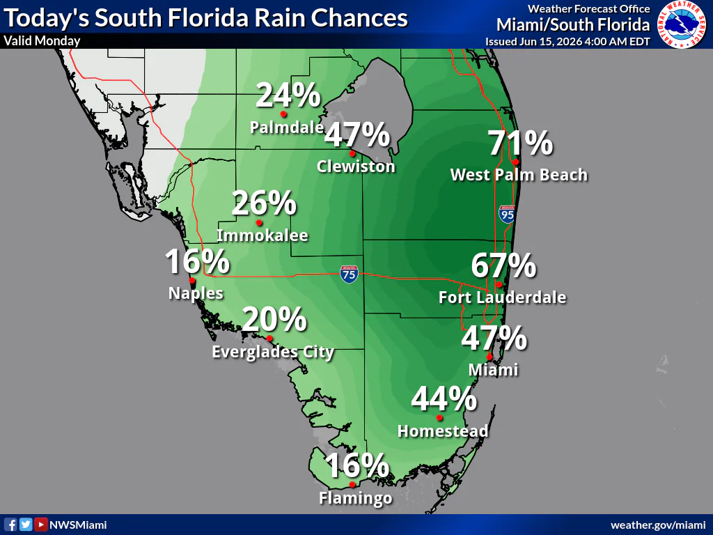
Today’s rain chances are highest along the east coast. West Palm Beach has a 71% chance of showers and thunderstorms, Fort Lauderdale 67%, Miami 47%, and Homestead 44%. Lower chances are expected in southwest Florida, with Naples and Flamingo around 16%.
Additionally, minor coastal flooding will be possible again today around this afternoon’s high tide cycle for coastal Collier and Mainland Monroe counties.
Showers and storms may produce heavy downpours, frequent lightning, and gusty winds. Isolated urban and poor drainage flooding is possible where heavier rain occurs.
Heat Safety Reminder: Stay hydrated, limit strenuous outdoor activity during the hottest part of the day, wear lightweight and light-colored clothing, and seek air conditioning when possible. Never leave children or pets in parked vehicles.
Storm Timing:
Possible Hazards:
Today (Monday)
A chance of showers and thunderstorms, mainly after noon. Partly sunny. High near 92°F. Heat index up to 106°F. Southeast wind 7 to 10 mph. New rainfall amounts between a quarter and half an inch possible in any storms.
Tonight
Mostly cloudy with a chance of showers and thunderstorms. Low around 78–79°F. East wind 6 to 10 mph.
Copyright 2023-2025 FloridaWord.com


