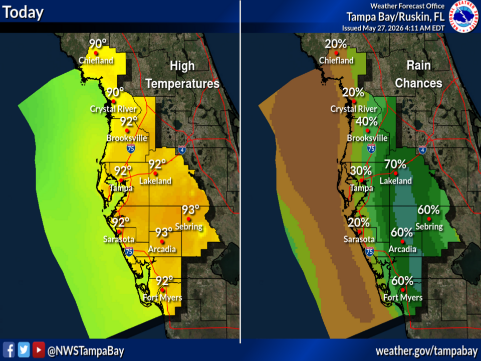
National Weather Service Tampa Bay Forecast for West Central and Southwest Florida on Wednesday, May 27, 2026.
TAMPA BAY, Florida – The National Weather Service Tampa Bay forecasts scattered to numerous mainly afternoon/evening showers and thunderstorms developing today, Wednesday, May 27, 2026, across west central and southwest Florida.
A pattern shift with south and southwest winds will direct the highest coverage of storms into the interior regions this afternoon and evening. Best chances for rain will be across the central and northern portions of the region, especially around Lakeland (70-75%), Brooksville (70-75%), and Crystal River.
High temperatures will reach the low-to-mid 90s across much of the area (around 90°–93° in most locations) with heat index values as high as 98 possible.
Moisture will remain elevated into Thursday and beyond, with a continued chance of scattered to numerous showers and thunderstorms at almost any hour plus locally heavy rainfall possible.
The National Weather Service (NWS) Tampa Bay has issued an updated forecast of scattered to numerous showers and thunderstorms developing this afternoon and evening, with the highest coverage expected across the interior due to the south/southwest wind shift.
The potential hazards include gusty winds, small hail, lightning, and locally heavy rainfall.
The forecast covers areas such as Tampa, St. Petersburg, Sarasota, Fort Myers, and northward toward the Nature Coast. Highest temperatures today will be in the interior; rain chances will be highest during the afternoon and evening hours, especially across the central and northern interior portions of the region.
Showers and thunderstorms are expected to become scattered to numerous during the afternoon and evening hours today.
Copyright 2023-2025 FloridaWord.com