Severe Thunderstorms, Hail, Tornado Risk For Central Florida
Published by
FLORIDA WORD
May 11, 2026 7:41 am
Share
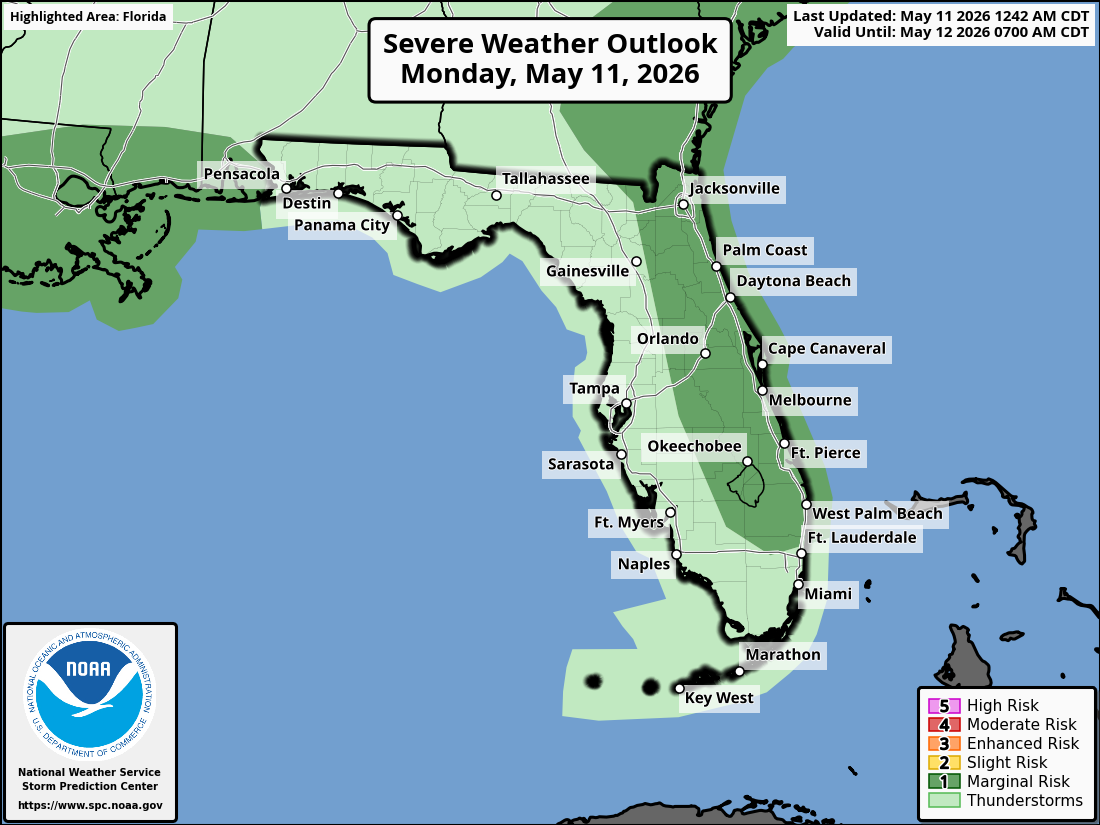
National Weather Service Storm Prediction Center Severe Weather Outlook for Florida on Monday, May 11, 2026.
ORLANDO, Florida – Hot and humid conditions continue across east Central Florida this Monday, May 11.
The National Weather Service in Melbourne forecasts scattered showers and thunderstorms developing this afternoon and evening, especially south of Orlando and Titusville. A storm or two could become strong to severe.
The National Weather Service Storm Prediction Center issued a Marginal (Level 1) Severe Storm Risk (out of 5) for much of east Central Florida today, including the Orlando metro area, Space Coast, and Treasure Coast.
National Weather Service Melbourne severe weather outlook graphic showing Marginal (Level 1) Risk of severe storms for Monday, May 11, 2026 (valid roughly 3PM-11PM).
The NWS warns of the following hazards during the peak storm hours this afternoon and evening on Monday:
Early season heat continues with Major Heat Risk across the Orlando metro, Space Coast, and Treasure Coast areas today (heat indices 95-102°F).
A Moderate Rip Current Risk remains in effect for all Atlantic beaches from Daytona through the Treasure Coast (1-2 ft surf). Swim near lifeguards and never swim against a rip current.
East Central Florida cities forecast to see very warm temperatures today include:
Orlando (high near 93°F, storms possible late afternoon/evening)
Daytona Beach (high near 90-92°F)
Melbourne (high near 91-93°F)
Vero Beach (high near 88-91°F)
Note: KMLB radar is now back in service following recent maintenance.
Orlando Weather Forecast
Today
A 40% chance of showers and thunderstorms mainly after 2pm. Mostly cloudy, with a high near 93. West southwest wind 5 to 10 mph. Chance of precipitation is 40%.
Tonight
A 30% chance of showers and thunderstorms before 11pm. Mostly cloudy, with a low around 73. West northwest wind around 5 mph becoming calm in the evening.
Tuesday
Showers likely and possibly a thunderstorm after 2pm. Mostly cloudy, with a high near 91. Chance of precipitation 60%.
Tuesday Night
A chance of showers and thunderstorms before 7pm, then showers likely and possibly a thunderstorm between 7pm and 2am, then a chance of showers after 2am. Mostly cloudy, with a low around 73. West wind around 5 mph becoming calm in the evening. Chance of precipitation is 60%.
Wednesday
A chance of showers before 11am, then a chance of showers and thunderstorms between 11am and 2pm, then showers likely and possibly a thunderstorm after 2pm. Mostly cloudy, with a high near 85. North wind 5 to 10 mph. Chance of precipitation is 70%.
Wednesday Night
Showers likely and possibly a thunderstorm before 8pm. Mostly cloudy, with a low around 70. Northeast wind 5 to 10 mph. Chance of precipitation is 60%.
Thursday
A 50 percent chance of showers and thunderstorms after 2pm. Partly sunny, with a high near 86. East northeast wind around 5 mph.
Thursday Night
A 30 percent chance of showers and thunderstorms before 8pm. Partly cloudy, with a low around 70. East wind around 5 mph becoming calm in the evening.