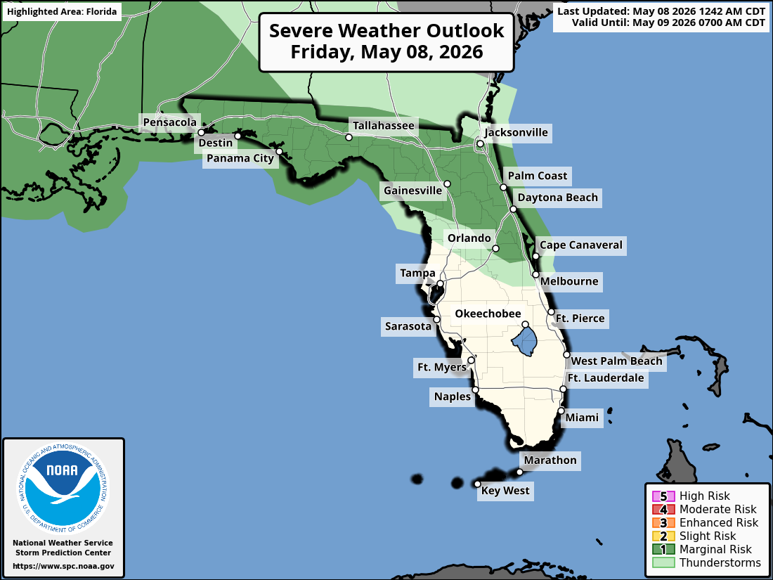
National Weather Service Storm Prediction Center Severe Weather Outlook for Florida on Friday, May 8, 2026.
ORLANDO, Florida – The National Weather Service in Melbourne has issued a Level 1 Severe Storm Risk (out of 5) for portions of east central Florida this afternoon through evening, particularly north of Cape Canaveral and the Orlando metro area.
Hot and humid conditions persist today with highs in the upper 80s to mid 90s and increasing humidity.
Scattered showers and thunderstorms will develop this afternoon across portions of the Florida Peninsula and may become more numerous this evening. A few storms could become strong to severe.
National Weather Service Melbourne strong storm risk graphic for east central Florida on Friday, May 8, 2026.
The NWS warns of the following hazards during the peak storm hours this afternoon and evening on Friday:
Frequent lightning strikes
Gusty winds 45-55 mph (15% chance of 60+ mph gusts)
Early season heat continues with Moderate to Major HeatRisk across the Orlando metro, Space Coast, and Treasure Coast areas through the weekend. Stay hydrated and limit time outdoors during the hottest parts of the day.
A Moderate Rip Current Risk remains in effect for all Atlantic beaches from Daytona through the Treasure Coast (1-2 ft surf). Swim near lifeguards and never swim against a rip current.
East Central Florida cities forecast to see very warm temperatures today include:
Orlando (92-94°F, storms possible in afternoon/evening)
Daytona Beach (high near 90°F)
Melbourne (high near 90-92°F)
Vero Beach (high near 88-92°F)
Note: KMLB radar is now back in service following recent maintenance.
Orlando Weather Forecast
Today
A slight chance of showers between 1pm and 2pm, then a chance of showers and thunderstorms after 2pm. Mostly sunny, with a high near 92. West northwest wind around 5 mph. Chance of precipitation is 30%.
Tonight
A chance of showers and thunderstorms before 11pm, then a slight chance of showers between 11pm and midnight. Mostly cloudy, with a low around 74. East northeast wind 5 to 10 mph becoming southeast after midnight. Chance of precipitation is 40%.
Saturday
Mostly sunny, with a high near 94. South wind 5 to 10 mph becoming west in the afternoon. Winds could gust as high as 20 mph.
Saturday Night
Increasing clouds, with a low around 74. West northwest wind around 5 mph becoming calm in the evening.
Sunday
A 30 percent chance of showers and thunderstorms after 2pm. Partly sunny, with a high near 93. Light west southwest wind becoming southwest 5 to 10 mph in the morning.
Sunday Night
A 30 percent chance of showers and thunderstorms before 8pm. Mostly cloudy, with a low around 75. South southwest wind around 5 mph becoming calm in the evening.