National Weather Service Storm Prediction Center Severe Weather Outlook for Florida February 15, 2026
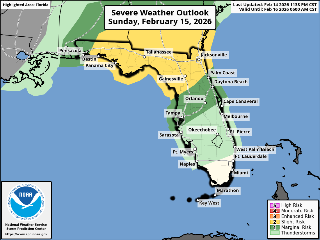
JACKSONVILLE, Florida – The National Weather Service Storm Prediction Center has issued a weather alert for North Florida and southeast Georgia on Sunday, February 15, 2026, due to a Level 2/5 (Slight) risk of strong-to-severe thunderstorms.
Thunderstorm activity is expected to develop as a squall line along a cold front, moving across northeast Florida and southeast Georgia during the afternoon and evening.
According to NWS Jacksonville, a squall line of strong-to-severe thunderstorms may develop, with the primary impacts across northeast Florida and southeast Georgia.
Stronger storms may produce:
Additionally, high wildfire danger is expected on Sunday due to gusty winds and extreme drought conditions. A Wind Advisory is in effect for frequent gusts of 35-45 mph, which may enhance the spread of any ongoing or new wildfires. Practice wildfire prevention measures.
Beneficial rainfall of 0.5-1.5 inches is expected, with locally higher amounts possible. Heavier downpours may lead to brief localized flooding in urban, low-lying, or poorly drained areas.
North Florida areas at risk for thunderstorms include:
Sunday
Showers and possibly a thunderstorm after 4pm, with strong to severe thunderstorms possible in a squall line during the afternoon and early evening. High near 80°F. Windy, with south winds 7 to 12 mph increasing to 15 to 20 mph in the afternoon, gusts up to 38 mph. Chance of precipitation is 80%, with new rainfall amounts between 0.5 and 0.75 inches possible. Hazards include gusty winds, isolated tornadoes, heavy rain, small hail, and frequent lightning.
Sunday Night
Showers and possibly a thunderstorm before 1am, then a chance of showers. Low around 58°F. Southwest winds 9 to 14 mph, with gusts as high as 23 mph. Chance of precipitation is 80%, with new rainfall amounts between 0.5 and 0.75 inches possible.
The NWS Jacksonville forecast indicates beneficial rainfall accumulation is expected with these storms, providing needed moisture after recent dry conditions, while the primary concerns remain damaging winds, tornadoes, and hail.
Copyright 2023-2025 FloridaWord.com


