National Weather Service Tampa Bay rain chances and high temperatures October 11, 2025
JACKSONVILLE, Florida – The National Weather Service in Jacksonville has issued a forecast for North Florida predicting continued impacts from a long-duration Nor’Easter through Sunday, October 12, 2025, with risks of moderate coastal flooding and minor tidal flooding, especially along the Atlantic coast and St. Johns River basin.
According to NWS Jacksonville, Coastal Flood Warnings remain in effect through tonight along the Atlantic coast and St. Johns River basin, with moderate tidal flooding continuing into early next week.
Dangerous marine and beach conditions persist, with gusty onshore winds through tonight. Minor tidal flooding is expected along the Atlantic coast on Sunday. Widespread moderate flooding is likely during high tides along the Atlantic coast and St. Johns River basin.
No active severe weather watches, but deadly rip current risk and rough surf continue through Sunday, along with a wind advisory through this evening and gale warnings for Atlantic waters through tonight.
Conditions are expected to improve on Monday, but small craft advisories will persist.
The ongoing Nor’Easter will continue to produce:
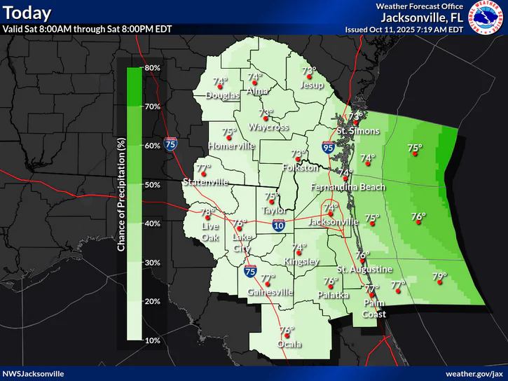
The greatest risk for flooding is along the coast and St. Johns River basin. There is also a chance of isolated showers, ranging from 20-40% across much of the region.
North Florida cities at risk for coastal flooding and gusty winds include regions such as:
Additionally, strong onshore winds on already elevated tides increase the risk for flooding, especially in urban, low-lying, and poor drainage areas. Minor to moderate coastal flooding during high tides through next week. Avoid flooded areas and never enter flood waters. Turn Around Don’t Drown!
Today (Saturday) Mostly sunny. High near 80. Breezy, with a northeast wind 10 to 15 mph, with gusts as high as 35 mph. Chance of precipitation is 20%.
Tonight A chance of showers and thunderstorms. Mostly cloudy, with a low around 68. Breezy, with a northeast wind around 14 mph, with gusts as high as 25 mph. Chance of precipitation is 40%.
Sunday A chance of showers. Mostly cloudy, with a high near 78. Northeast wind 10 to 15 mph, with gusts as high as 25 mph. Chance of precipitation is 40%.
Sunday Night A 30 percent chance of showers. Mostly cloudy, with a low around 70. Northeast wind around 10 mph, with gusts as high as 20 mph.
Copyright 2023-2025 FloridaWord.com


