NOAA National Hurricane Center Tropical Storm Jerry Projected Path
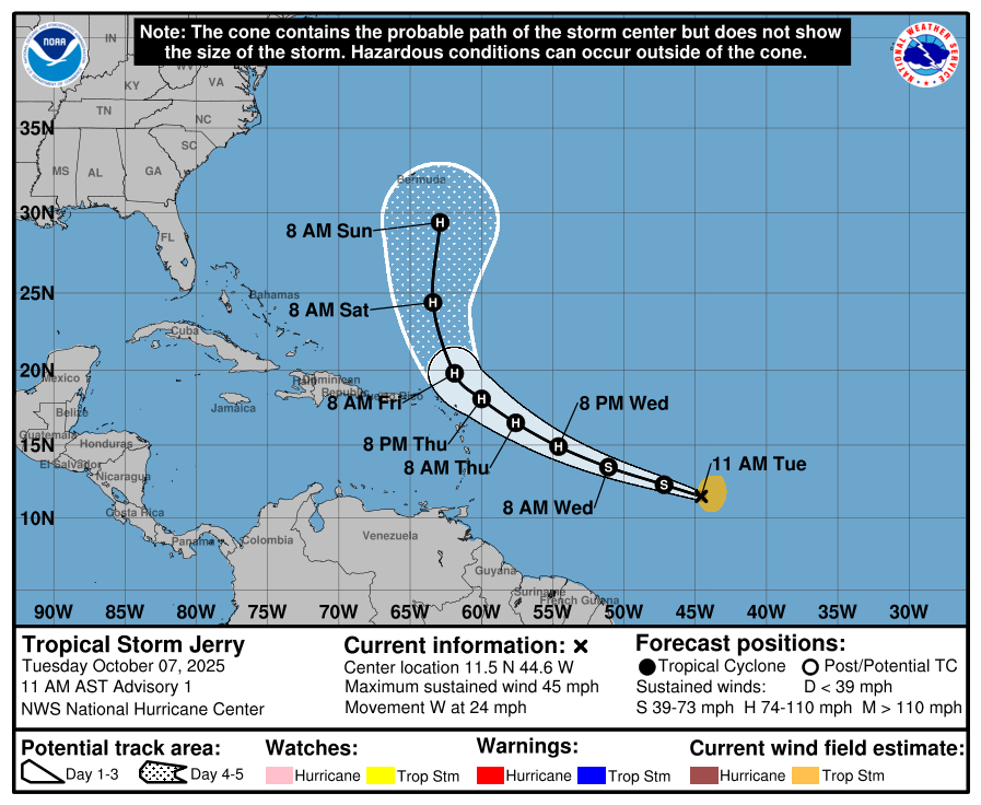
MIAMI, Florida – NOAA‘s National Hurricane Center issued a Public Advisory at 11 a.m. Eastern Daylight Time on Tuesday, October 7, 2025, for Tropical Storm Jerry, which strengthened from Invest 95L earlier this week while moving westward over the tropical central Atlantic.
There are no coastal watches or warnings in effect.
Interests in the northern Leeward Islands should monitor the progress of this system as Tropical Storm Watches could be required later today or tonight.
Tropical Storm Jerry is located about 1315 miles (2120 km) east-southeast of the northern Leeward Islands and is moving to the west at 24 mph (39 km/h).
NHC forecasters say that a decrease in forward speed and a turn to the west-northwest is expected during the next couple of days.
On the official NHC forecast track, the center of the tropical cyclone is expected to be near or to the north of the northern Leeward Islands late Thursday and Friday and then turn northward over the west-central Atlantic this weekend.
Computer models, often referred to as spaghetti models, are in good agreement through 72 hours that the system will move westward then west-northwestward toward the northern Leeward Islands.
After 72 hours, the models show low confidence with a bifurcation of solutions, showing a spread in the northward turn with some tracks bringing the system closer to the southeastern U.S. coast while others recurve farther offshore, but the track guidance this cycle is a little faster than the model consensus through 72 hours, and quite a bit of along-track spread remains in the 4-5 day time frame.
A majority of computer models suggest the system will turn northward over the west-central Atlantic, with much more acceleration at the end of the forecast period. Both the ECMWF (European model) and GFS (American model) agree with this scenario.
Some ensemble members still show it reaching closer to land. There is considerable uncertainty in the timing and speed of this northward turn. Recent trends indicate uncertainty on how close the core will get to the northern Leeward Islands, reducing the chance of direct landfall along the islands but still posing risks of heavy rain and coastal impacts.
The official NHC forecast track is a little faster than the model consensus through 72 hours and in best agreement with HCCA and the Google DeepMind ensemble mean (GDMI).
Tropical Storm Jerry has maximum sustained winds of 45 mph (75 km/h), with higher gusts.
Strengthening is expected during the next few days, with the system forecast to become a hurricane in a day or two.
NOAA forecasts an “above-normal” 2025 Atlantic Hurricane Season, which runs from June 1 through November 30.
The peak of hurricane season occurs in September and early October, with historical data from NOAA and the National Weather Service showing increased tropical storm and hurricane activity during this period.
Copyright 2023-2025 FloridaWord.com


