NOAA National Hurricane Center Tropical Weather Outlook for October 6, 2025.
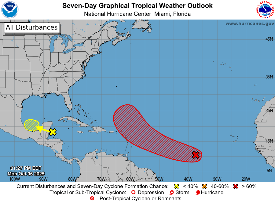
MIAMI, Florida – NOAA‘s National Hurricane Center in Miami, Florida, issued a Tropical Weather Outlook at 2 p.m. Eastern Daylight Time on Monday, October 6, 2025, due to the presence of Invest 95L located over the tropical central Atlantic.
If Invest 95L develops into a tropical storm or hurricane, the next name on the 2025 Atlantic Hurricane List is Jerry.
Invest 95L is an area of low pressure associated with a low-latitude tropical wave that is gradually becoming better organized, producing a large area of disorganized showers and thunderstorms over the tropical central Atlantic.
NHC forecasters say that environmental conditions appear generally conducive for slow development of this system.
A tropical depression is likely to form within the next couple of days while it moves quickly west-northwestward across the central tropical Atlantic, expected to be near or north of the northern Leeward Islands on Thursday and Friday.
Interests there should monitor the progress of this system.
This system has an 80% chance of tropical cyclone formation within the next 7 days and a 70% chance within the next 48 hours.
Computer models, often referred to as spaghetti models, show the system moving westward across the tropical Atlantic toward the Lesser Antilles.
The models indicate potential development, with variations in track and intensity. Some models suggest it could strengthen gradually under favorable conditions, potentially reaching tropical storm or hurricane strength as it approaches the Leeward Islands.
Models such as the GFS (American model) and ECMWF (European model) vary, with ensembles showing a spread in possible paths, some curving northward after the islands, while others continue westward.
Despite the trends, forecasts remain uncertain until a well-defined center forms.
NOAA forecasts an “above-normal” 2025 Atlantic Hurricane Season, which runs from June 1 through November 30.
Peak hurricane season was September 10 according to NOAA and the National Weather Service‘s historical hurricane activity data.
Copyright 2023-2025 FloridaWord.com


