National Weather Service Miami South Florida Rain Chances October 11, 2025
MIAMI, FL — The National Weather Service in Miami has issued a forecast of scattered showers and isolated thunderstorms across South Florida today, Saturday, October 11, 2025, with the best chances late morning into early afternoon amid seasonably warm temperatures in the mid 80s.
Showers and storms may produce heavy downpours leading to isolated urban flooding. Conditions are expected to improve tonight as a front approaches, bringing drier air for the weekend.
Temperatures will reach 82 to 86°F, with humidity making heat indices in the low to mid 90s.
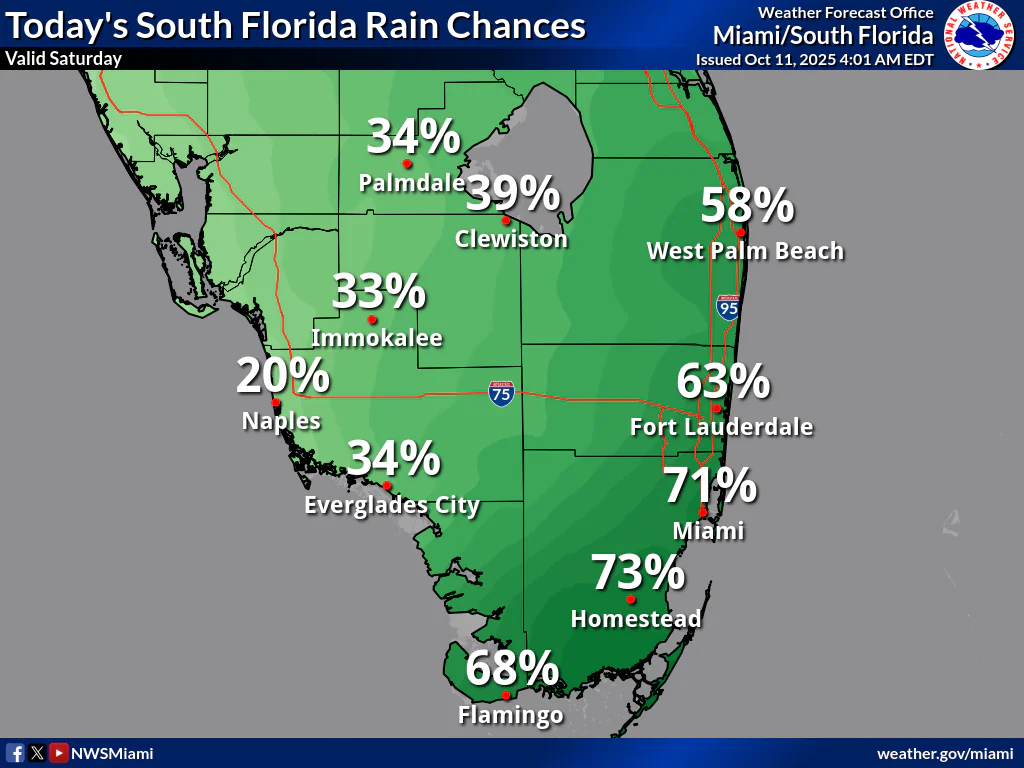
Rainfall chances today are low to moderate, with Palmdale at 34%, Clewiston at 39%, West Palm Beach at 58%, Immokalee at 33%, Naples at 20%, Everglades City at 34%, Fort Lauderdale at 63%, Miami at 71%, Homestead at 73%, and Flamingo at 68%, according to the NWS forecast. These probabilities show scattered shower and isolated thunderstorm activity across South Florida, with potential for localized heavy rainfall.
Storm Timing:
Possible Hazards:
Today
Scattered showers and isolated thunderstorms, mainly late morning into early afternoon. Mostly sunny, with a high near 82°F. Heat index values as high as 92°F. East wind 5 to 10 mph. Chance of precipitation is 70%. New rainfall amounts between a tenth and quarter of an inch possible.
Tonight
A 20 percent chance of showers before midnight. Partly cloudy, with a low around 74°F. East wind around 5 mph becoming calm.
Sunday
A 30 percent chance of showers after 2pm. Sunny, with a high near 85°F. Calm wind becoming east 5 to 8 mph in the afternoon.
Sunday Night
A 20 percent chance of showers before 11pm. Partly cloudy, with a low around 75°F. East wind around 5 mph becoming calm.
Monday
A 20 percent chance of showers after 2pm. Sunny, with a high near 85°F. Calm wind becoming east around 6 mph in the afternoon.
Monday Night
A 10 percent chance of showers. Partly cloudy, with a low around 75°F. Light east wind.
Copyright 2023-2025 FloridaWord.com


