National Weather Service Miami South Florida Rain Chances October 11, 2025
MIAMI, Florida — The National Weather Service in Miami has issued a forecast of scattered showers and thunderstorms across South Florida today, Sunday, October 5, 2025, with rain chances higher along the east coast metro areas amid breezy conditions and near-normal temperatures.
Showers and storms may produce heavy downpours, frequent lightning, and gusty winds. Excessive rainfall could lead to isolated urban and poor drainage flooding, with reduced visibility.
Additionally, a Coastal Flood Advisory is in effect until October 6 due to astronomical high tides (King tides) from October’s Supermoon, with high rip current risk and elevated surf along Palm Beach County.
Temperatures will reach 85 to 90°F, with high humidity amplifying heat indices around 95 to 100°F.
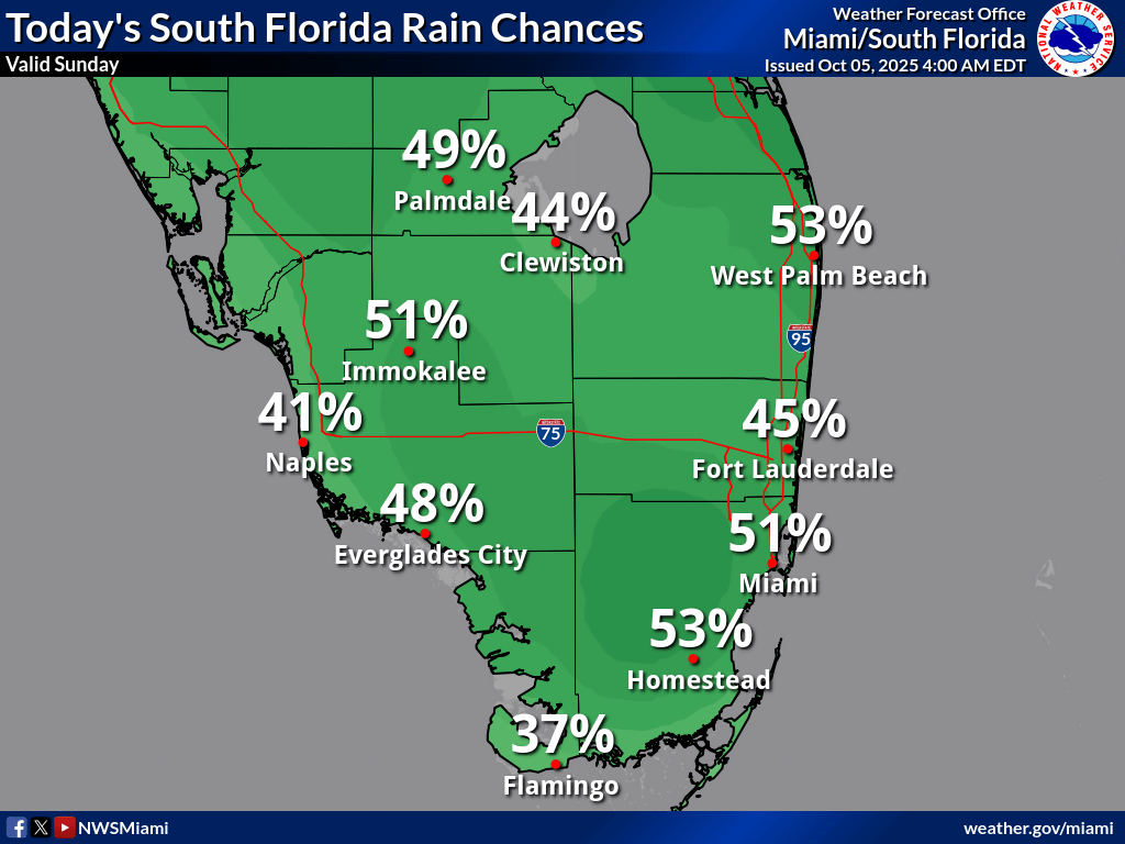
Rainfall chances today are low to moderate, with Palmdale at 49%, Clewiston at 44%, West Palm Beach at 53%, Immokalee at 51%, Naples at 41%, Everglades City at 48%, Fort Lauderdale at 45%, Miami at 51%, Homestead at 53%, and Flamingo at 37%, according to the NWS forecast.
Storm Timing:
Possible Hazards:
Today
A 50 percent chance of showers and thunderstorms. Partly sunny, with a high near 87°F. Southeast wind 7 to 9 mph becoming northeast in the morning. New rainfall amounts between a quarter and half of an inch possible.
Tonight
A 30 percent chance of showers and thunderstorms. Mostly cloudy, with a low around 79°F. East wind 6 to 8 mph.
Monday
A 50 percent chance of showers and thunderstorms. Mostly sunny, with a high near 87°F. East wind 6 to 10 mph.
Monday Night
A 50 percent chance of showers and thunderstorms. Mostly cloudy, with a low around 79°F. East wind around 10 mph.
Tuesday
A 50 percent chance of showers and thunderstorms. Partly sunny, with a high near 87°F. East wind 8 to 11 mph.
Tuesday Night
A 40 percent chance of showers and thunderstorms. Mostly cloudy, with a low around 78°F. East wind around 9 mph.
Copyright 2023-2025 FloridaWord.com


