National Weather Service Miami South Florida Rain Chances September 13, 2025
MIAMI, FL — The National Weather Service in Miami has issued a forecast of likely showers and thunderstorms across South Florida today, Saturday, September 13, 2025, with high rain chances throughout the region amid below-normal temperatures due to an unsettled weather pattern.
Showers and thunderstorms are expected to develop this afternoon and evening, with additional activity possible overnight. Heavy downpours could lead to additional urban and flash flooding concerns through today, with multiple rounds of rain increasing the risk. Minor coastal flooding is possible along the east coast during high tide cycles.
Temperatures will reach near 86°F, with humidity keeping conditions muggy but heat indices not exceeding dangerous levels.
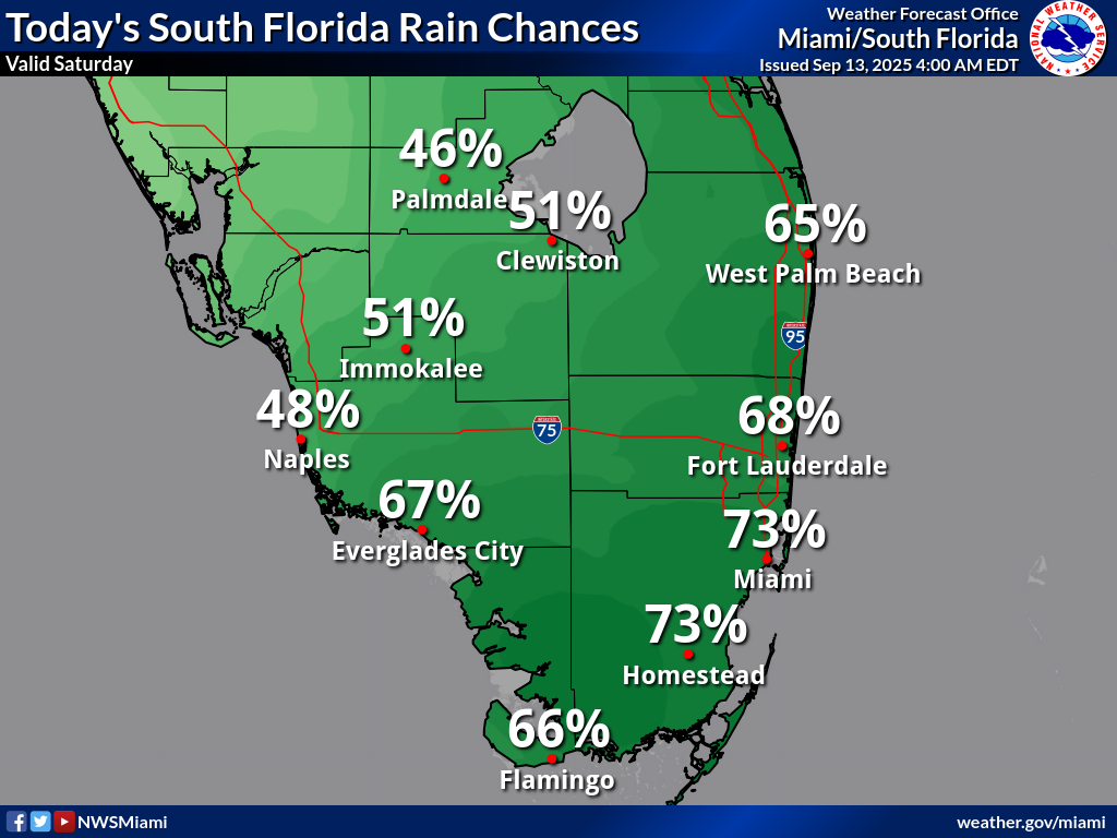
Rainfall chances today are high, with Palmdale at 51%, Clewiston at 51%, West Palm Beach at 65%, Immokalee at 48%, Naples at 67%, Everglades City at 73%, Fort Lauderdale at 73%, Miami at 73%, Homestead at 66%, and Flamingo at 66%, according to the NWS forecast.
These probabilities indicate likely shower and thunderstorm activity across South Florida, with potential for localized heavy rainfall up to 2-3 inches in isolated areas today.
Storm Timing:
Possible Hazards:
Today
Showers and thunderstorms likely. Partly sunny, with a high near 86°F. Northeast wind around 9 mph. Chance of precipitation is 60%. New rainfall amounts between a tenth and quarter of an inch, except higher amounts possible in thunderstorms.
Tonight
A 50 percent chance of showers and thunderstorms. Mostly cloudy, with a low around 77°F. North wind around 7 mph.
Sunday
A 40 percent chance of showers and thunderstorms. Mostly sunny, with a high near 87°F. North wind 6 to 8 mph becoming east in the afternoon.
Sunday Night
A 30 percent chance of showers and thunderstorms, mainly before 2am. Partly cloudy, with a low around 78°F. Northeast wind around 6 mph.
Copyright 2023-2025 FloridaWord.com


