National Weather Service Miami South Florida Rain Chances September 18, 2025
MIAMI, FL — The National Weather Service in Miami has issued a forecast of scattered to numerous showers and thunderstorms across South Florida today, Thursday, September 18, 2025, with rain chances favoring the east coast metro areas amid below normal temperatures.
A few storms may become strong this afternoon, capable of producing gusty winds and heavy downpours. Excessive rainfall could lead to localized urban and poor drainage flooding, especially along the east coast.
Temperatures will reach the mid to upper 80s, with high humidity amplifying heat indices near 95°F.
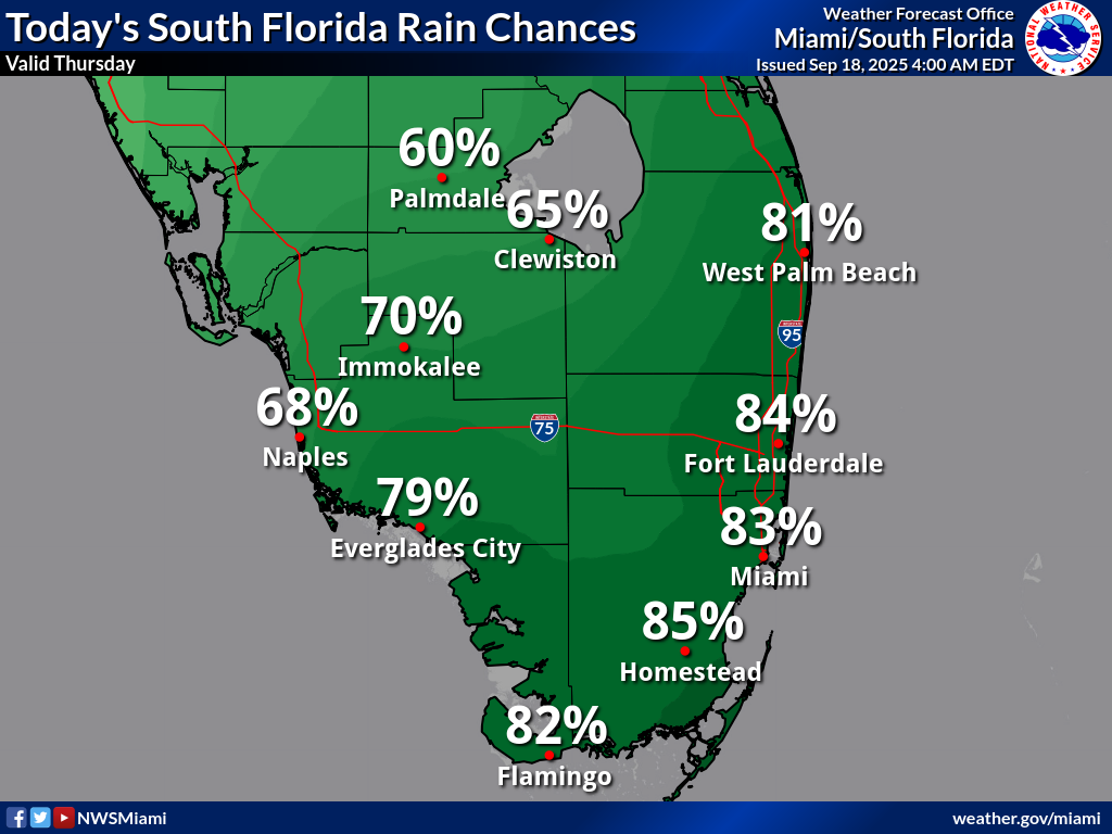
Rainfall chances today are moderate to high, with Palmdale at 65%, Clewiston at 70%, West Palm Beach at 81%, Immokalee at 68%, Naples at 79%, Everglades City at 74%, Fort Lauderdale at 84%, Miami at 85%, Homestead at 82%, and Flamingo at 75%, according to the NWS forecast. These probabilities show scattered to numerous shower and thunderstorm activity across South Florida, with potential for localized heavy rainfall.
Storm Timing:
Possible Hazards:
National Weather Service Miami South Florida Doppler Radar
Today
Showers and thunderstorms likely. Mostly cloudy, with a high near 86°F. South wind 5 to 10 mph. Chance of precipitation is 80%. New rainfall amounts between a quarter and half of an inch possible.
Tonight
Showers and thunderstorms. Low around 77°F. South wind around 5 mph. Chance of precipitation is 80%. New rainfall amounts of less than a tenth of an inch, except higher amounts possible in thunderstorms.
Friday
Rounds of heavy showers and thunderstorms. High near 85°F. Chance of precipitation is 90%.
Friday Night
Showers and thunderstorms likely. Low around 76°F. Chance of precipitation is 70%.
Copyright 2023-2025 FloridaWord.com


