National Weather Service Miami South Florida Rain Chances September 21, 2025
MIAMI, FL — The National Weather Service in Miami has issued a forecast of isolated showers along the east coast during the morning and early afternoon hours today, Sunday, September 21, 2025, with a few thunderstorms possibly developing during the late afternoon and early evening hours amid near-normal temperatures.
Thunderstorms may produce gusty winds, heavy downpours, and lightning. Excessive rainfall could lead to isolated flooding in poor drainage areas, with reduced visibility.
Temperatures will reach 87 to 92°F, with high humidity amplifying heat indices to 97 to 103°F.
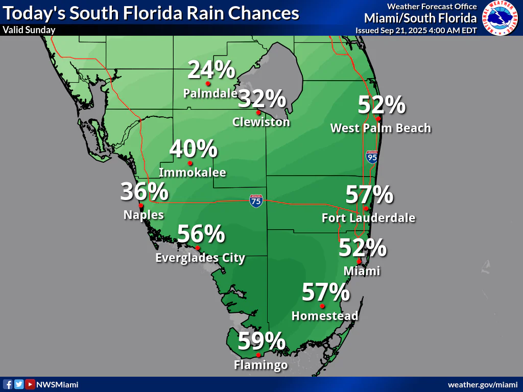
Rainfall chances today are moderate, with Palmdale at 24%, Clewiston at 32%, West Palm Beach at 52%, Immokalee at 40%, Naples at 36%, Everglades City at 56%, Fort Lauderdale at 57%, Miami at 52%, Homestead at 57%, and Flamingo at 59%, according to the NWS forecast. These probabilities show isolated to scattered shower and thunderstorm activity across South Florida, with potential for localized heavy rainfall.
Storm Timing:
Possible Hazards:
National Weather Service Miami South Florida Doppler Radar
Today
A chance of showers and thunderstorms. Mostly sunny, with a high near 88°F. Heat index values as high as 100°F. East wind 5 to 10 mph. Chance of precipitation is 50%.
Tonight
A 30 percent chance of showers and thunderstorms. Mostly cloudy, with a low around 78°F. East wind around 5 mph.
Monday
A 40 percent chance of showers and thunderstorms. Mostly sunny, with a high near 88°F. Heat index values as high as 100°F. East wind 5 to 10 mph.
Monday Night
A 30 percent chance of showers and thunderstorms. Mostly cloudy, with a low around 78°F. East wind around 5 mph.
Tuesday
A 40 percent chance of showers and thunderstorms. Mostly sunny, with a high near 88°F. East wind 5 to 10 mph.
Tuesday Night
A 30 percent chance of showers and thunderstorms. Mostly cloudy, with a low around 78°F. East wind around 5 mph.
Copyright 2023-2025 FloridaWord.com


