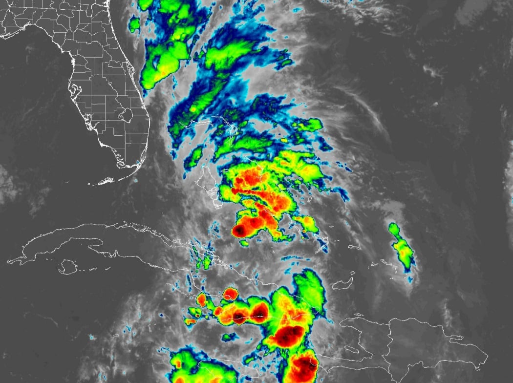
NOAA GOES East Satellite Imagery of Tropical Depression Nine and Florida September 28, 2025
MIAMI, FL — The National Weather Service in Miami has issued a forecast of scattered to numerous showers and thunderstorms across South Florida today, Sunday, September 28, 2025, influenced by Tropical Depression Nine passing to the east, with rain chances higher along the east coast amid breezy conditions and slightly below-normal temperatures.
Periods of gusty showers and storms are possible throughout the day, with some becoming strong, capable of producing gusty winds up to 25 mph, heavy downpours, and frequent lightning. Excessive rainfall could lead to isolated urban and poor drainage flooding, with reduced visibility. Deteriorating marine conditions are expected, with tropical storm watches and warnings in effect for Atlantic waters.
Temperatures will reach 87 to 90°F, with high humidity potentially amplifying heat indices over 100°F.
Rainfall chances today are moderate to high, with Palmdale at 67%, Clewiston at 68%, West Palm Beach at 80%, Immokalee at 61%, Naples at 51%, Everglades City at 60%, Fort Lauderdale at 76%, Miami at 75%, Homestead at 70%, and Flamingo at 61%, according to the NWS forecast. These probabilities show scattered to numerous shower and thunderstorm activity across South Florida, with potential for localized heavy rainfall.
Storm Timing:
Possible Hazards:
Today
Showers and thunderstorms likely, mainly before 5pm. Partly sunny, with a high near 87°F. Heat index values as high as 100°F. Breezy, with a northeast wind 10 to 17 mph, with gusts as high as 25 mph. Chance of precipitation is 60%. New rainfall amounts between a quarter and half of an inch possible.
Tonight
A 30 percent chance of showers and thunderstorms, mainly before 9pm. Mostly cloudy, with a low around 78°F. Northeast wind around 6 mph.
Monday
A 50 percent chance of showers and thunderstorms. Partly sunny, with a high near 88°F. Breezy, with a northeast wind 10 to 15 mph, with gusts as high as 20 mph.
Monday Night
A 40 percent chance of showers and thunderstorms. Mostly cloudy, with a low around 79°F. East wind around 8 mph.
Tuesday
Showers likely and possibly a thunderstorm. Partly sunny, with a high near 88°F. East wind 9 to 13 mph. Chance of precipitation is 60%.
Tuesday Night
A 50 percent chance of showers and thunderstorms. Mostly cloudy, with a low around 80°F. East wind around 10 mph.
Copyright 2023-2025 FloridaWord.com


