National Weather Service Tampa Bay rain chances and high temperatures September 12, 2025
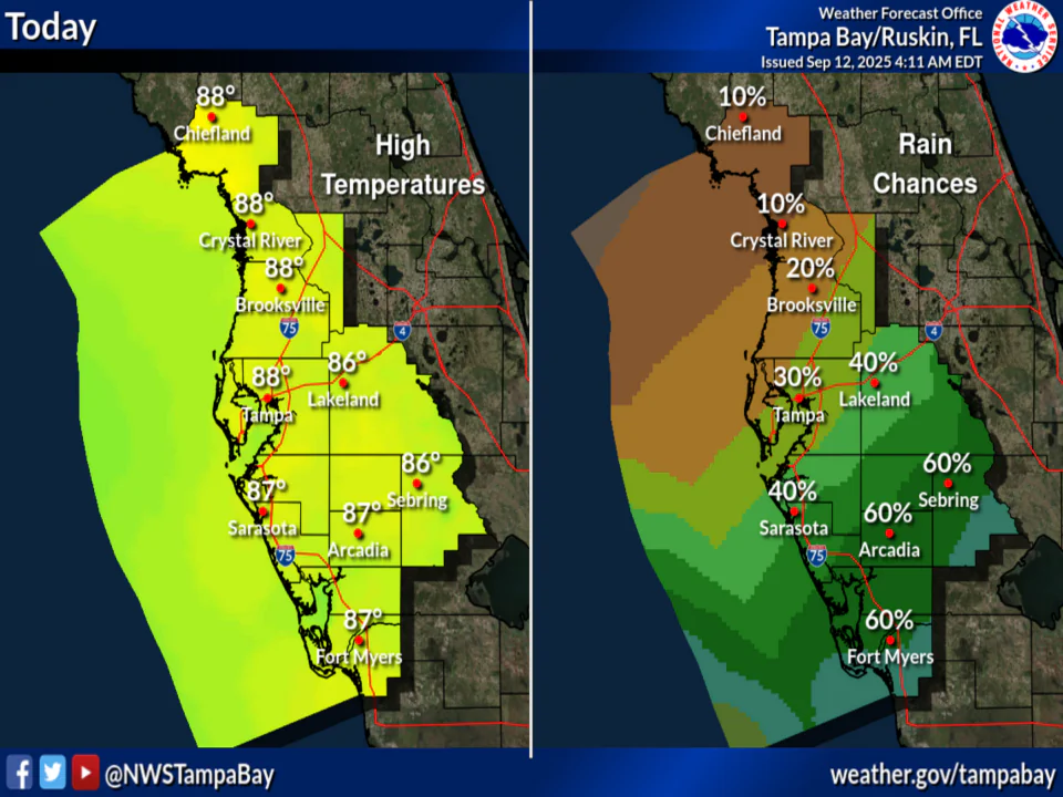
TAMPA BAY, Florida – The National Weather Service (NWS) Tampa Bay has issued a forecast for west Central Florida and Southwest Florida on Friday, September 12, 2025, forecasting scattered showers and thunderstorms mainly in the afternoon with highs in the upper 80s across the region. Rain chances lower for most areas except higher in Southwest Florida. Rain chances vary from 20% in northern areas like Chiefland to 50% in southern areas like Fort Myers.
The forecast covers areas such as Tampa, St. Petersburg, Sarasota, and Fort Myers.
Today
Scattered showers and thunderstorms, mainly after 5pm. Mostly cloudy, with a high near 88. North northeast wind around 8 mph. Chance of precipitation is 30%.
Tonight
Scattered showers and thunderstorms before 8pm. Mostly cloudy, then gradually becoming mostly clear, with a low around 72. North northeast wind 6 to 9 mph. Chance of precipitation is 30%.
Saturday
Scattered showers and thunderstorms after 2pm. Sunny, with a high near 90. Northeast wind around 9 mph. Chance of precipitation is 30%.
Saturday Night
Scattered showers and thunderstorms before 8pm. Mostly clear, with a low around 71. Northeast wind 7 to 10 mph. Chance of precipitation is 30%.
Sunday
Isolated showers and thunderstorms after 2pm. Sunny, with a high near 89. North northeast wind around 8 mph. Chance of precipitation is 20%.
Sunday Night
Isolated showers and thunderstorms before 8pm. Mostly clear, with a low around 70. North northeast wind 5 to 8 mph. Chance of precipitation is 10%.
Copyright 2023-2025 FloridaWord.com

