NOAA National Hurricane Center Tropical Storm Imelda Projected Path
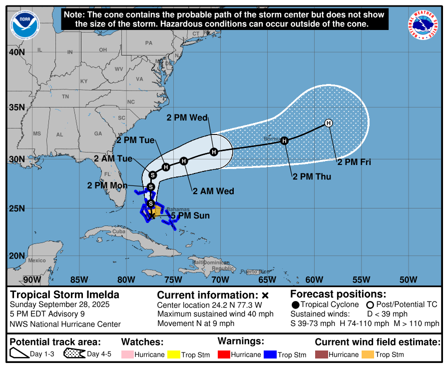
MIAMI, Florida – NOAA‘s National Hurricane Center issued a Public Advisory at 5 p.m. Eastern Daylight Time on Sunday, September 28, 2025, for Tropical Storm Imelda, which strengthened from Invest 94L, Potential Tropical Cyclone Nine, and Tropical Depression Nine earlier this weekend while moving northward near the central Bahamas.
A Tropical Storm Warning is in effect for the central Bahamas, including Cat Island, the Exumas, Long Island, Rum Cay, and San Salvador, and portions of the northwestern Bahamas, including Eleuthera, New Providence, the Abacos, Berry Islands, Andros Island, and Grand Bahama Island.
The Tropical Storm Watch has been discontinued for the east coast of Florida from the Palm Beach County / Martin County Line northward to the Flagler County / Volusia County Line.
Interests elsewhere in the Bahamas and along the southeast coast of the United States from Florida to North Carolina should monitor the progress of this system.
Tropical Storm Imelda is located about 55 miles (90 km) south-southwest of the Northwest Bahamas and about 355 miles (570 km) southeast of Cape Canaveral, Florida, and is moving to the north at 9 mph (15 km/h).
NHC forecasters say that a faster motion to the north is expected tonight and continuing through Monday.
On the official NHC forecast track, the center of the tropical cyclone is expected to move across the central and northwestern Bahamas this afternoon and tonight and then turn sharply east-northeastward starting on Tuesday, moving away from the southeastern U.S. by the middle part of this week.
Computer models, often referred to as spaghetti models, are in good agreement through 72 hours that the system will move northward across the central and northwestern Bahamas, remaining offshore the east coast of Florida.
After 72 hours, the models show low confidence with a bifurcation of solutions, but the track guidance this cycle has finally started to stabilize near the previous forecast track, though is still a tick faster than the previous forecast cycle, and quite a bit of along-track spread remains in the 4-5 day time frame.
A majority of computer models suggest the system will slow down or stall offshore of the southeast U.S. coast before turning sharply east-northeastward, with much more acceleration at the end of the forecast period. Both the ECMWF (European model) and GFS (American model) agree with this scenario.
Some ensemble members still show it reaching the coast. There is considerable uncertainty in the timing and speed of this eastward turn. Recent trends indicate an eastward shift, potentially influenced by Hurricane Humberto, reducing the chance of direct landfall along the Carolinas but still posing risks of heavy rain and coastal impacts.
The official NHC forecast track lies in between the GFS and ECMWF track solutions, closest to but not quite as fast as the Google DeepMind ensemble mean (GDMI).
Tropical Storm Imelda has maximum sustained winds of 40 mph (65 km/h), with higher gusts.
Strengthening is expected during the next few days, with the system forecast to become a hurricane by late Monday or Tuesday.
NOAA forecasts an “above-normal” 2025 Atlantic Hurricane Season, which runs from June 1 through November 30.
September marks the peak of hurricane season, with historical data from NOAA and the National Weather Service showing increased tropical storm and hurricane activity during this period.
Copyright 2023-2025 FloridaWord.com


