NOAA National Hurricane Center Hurricane Imelda Projected Path
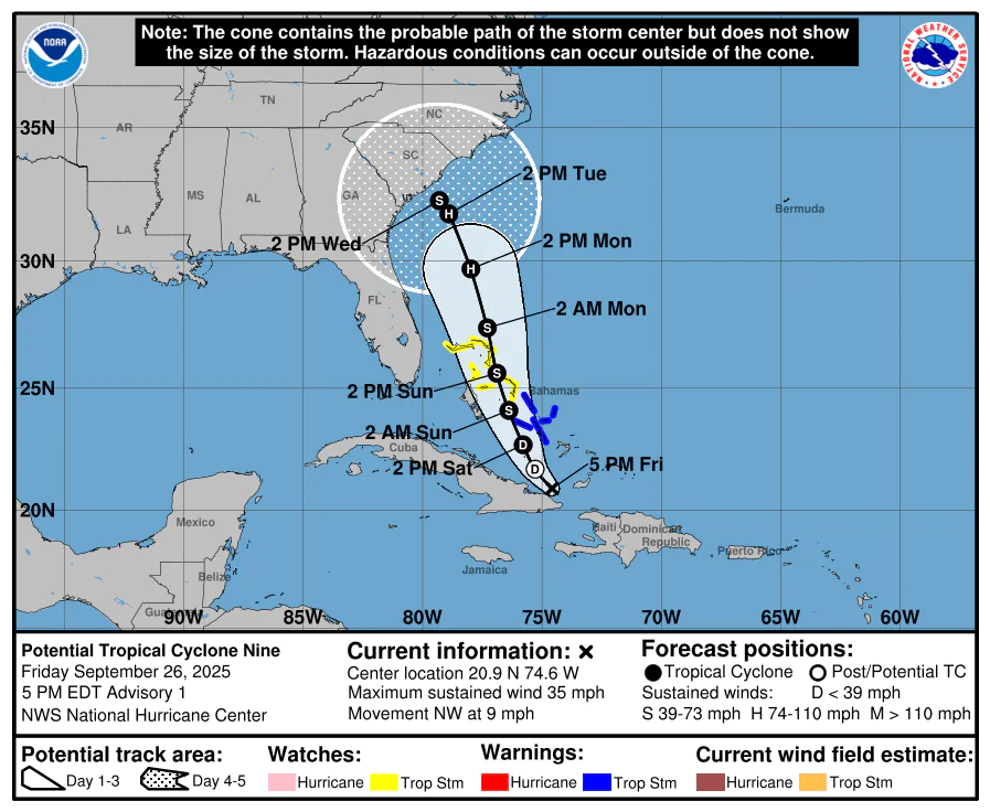
MIAMI, Florida – NOAA‘s National Hurricane Center issued a Public Advisory at 5:00 p.m. Eastern Daylight Time on Friday, September 26, 2025, for Potential Tropical Cyclone Nine, which is developing from Invest 94L while moving northwestward near eastern Cuba.
A Tropical Storm Warning is in effect for the central Bahamas, including Cat Island, the Exumas, Long Island, Rum Cay, and San Salvador.
A Tropical Storm Watch is in effect for portions of the northwestern Bahamas, including Eleuthera, New Providence, the Abacos, Berry Islands, and Grand Bahama Island.
Interests in eastern Cuba, the southeast Bahamas, the Turks and Caicos Islands, and the southeastern U.S. should monitor the progress of this system.
Potential Tropical Cyclone Nine is located near latitude 20.9 North, longitude 74.6 West, about 55 miles north-northwest of the eastern tip of Cuba and about 200 miles south-southeast of the central Bahamas, and is moving to the northwest at 9 mph (15 km/h).
NHC forecasters say that a north-northwestward motion is expected during the next few days.
On the official NHC forecast track, the center of the system is expected to track across the central and northwestern Bahamas this weekend and approach the southeast U.S. coast early next week, with potential impacts to portions of the southeast U.S.
Computer models, often referred to as spaghetti models, show Potential Tropical Cyclone Nine moving north-northwestward across the Bahamas, with models in good agreement through the weekend.
After the weekend, the models diverge significantly, with scenarios including continued north-northwestward movement to landfall in the Carolinas, or stalling off the Southeast coast before drifting eastward, possibly toward Bermuda. There is some spread in the forecast track, particularly regarding long-range movements and potential impacts.
The official NHC forecast track is in best agreement with the EMXI model.
Potential Tropical Cyclone Nine has maximum sustained winds of 35 mph (55 km/h), with higher gusts.
Gradual strengthening is expected during the next few days, but the system is forecast to become a tropical depression on Saturday and a tropical storm Saturday night or early Sunday, potentially reaching hurricane strength early next week.
NOAA forecasts an “above-normal” 2025 Atlantic Hurricane Season, which runs from June 1 through November 30.
September marks the peak of hurricane season, with historical data from NOAA and the National Weather Service showing increased tropical storm and hurricane activity during this period.
Copyright 2023-2025 FloridaWord.com


