NOAA National Hurricane Center Tropical Weather Outlook for September 26, 2025.
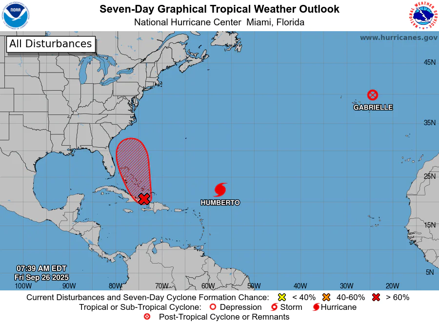
MIAMI, Florida – NOAA‘s National Hurricane Center in Miami, Florida, issued a Tropical Weather Outlook at 8 a.m. Eastern Daylight Time on Friday, September 26, 2025, due to the presence of Invest 94L located over the central Caribbean Sea.
If Invest 94L develops into a tropical storm or hurricane, the next name on the 2025 Atlantic Hurricane List is Imelda.
Invest 94L is a tropical wave that is producing a large area of increasing showers, thunderstorms, and gusty winds near Hispaniola, the Turks and Caicos Islands, and eastern Cuba (marked with a red shaded area).
NHC forecasters say that an area of low pressure is expected to form along the wave by tonight when it moves near the southeast Bahamas.
This low is expected to become a tropical depression when it is in the vicinity of the central and northwest Bahamas over the weekend, and then track northwestward or northward over the southwestern Atlantic.
Regardless of development, heavy rains and gusty winds are ongoing in the Dominican Republic, Haiti, and the Turks and Caicos Islands, and are likely to spread across the Bahamas and eastern Cuba during the next day or two. Interests in all of these areas should monitor the progress of the system.
While there remains considerable uncertainty in the long-range track and intensity of the system, there is a significant risk of wind, rainfall, and storm surge impacts for a portion of the southeast U.S. coast early next week. Interests in this area should also monitor the progress of the system.
This system has a 90% chance of tropical cyclone formation within the next 7 days and an 80% chance within the next 48 hours.
Computer models, often referred to as spaghetti models, are in general agreement during the first 48 hours that the system will move west-northwestward near or over the Dominican Republic, Turks and Caicos, and eastern Cuba.
After 48 hours, the models have trended westward in recent runs, with a growing consensus showing the system moving northwestward through the southeastern and central Bahamas, then curving northward parallel to or over the east coast of Florida, before potentially making landfall along the southeastern U.S. coast, particularly between Georgia and North Carolina.
The latest spaghetti models from the 00Z run on September 26, 2025, indicate a cluster of tracks aiming toward the Carolinas, with some models showing an inland path through South Carolina and others remaining slightly offshore or turning eastward. Models such as the GFS (American model) suggest potential development into a Category 1 hurricane, while the ECMWF (European model) and others vary in intensity from tropical storm to weak hurricane strength.
The interaction with Tropical Storm Humberto adds uncertainty, as its path could influence whether Invest 94L is steered toward land or pulled out to sea. Despite the trends, forecasts remain uncertain until a well-defined center forms.
NOAA forecasts an “above-normal” 2025 Atlantic Hurricane Season, which runs from June 1 through November 30.
Peak hurricane season was September 10 according to NOAA and the National Weather Service‘s historical hurricane activity data.
Copyright 2023-2025 FloridaWord.com


