National Weather Service Tallahassee Forecast for Florida Panhandle and Big Bend
TALLAHASSEE, Florida – The National Weather Service Tallahassee forecasts showers and thunderstorms for the Florida Big Bend and far south Georgia on Friday, September 26, 2025. A cold front will bring numerous showers and storms, with locally heavy rain possible, but flood concerns are low as much of this rainfall should be beneficial given ongoing drought conditions.
Meteorologists anticipate rainfall amounts ranging from a quarter to a half inch areawide, with isolated amounts over 1 inch. There is a 10% chance of exceeding 2 inches along the Northeast Gulf Coast and west of I-75.
Showers and thunderstorms are expected mainly after noon today, with higher chances continuing through the weekend.
While heavy rain may be isolated, be prepared to head indoors when storms approach due to lightning risks and potential local runoff issues in urban or low-lying areas.
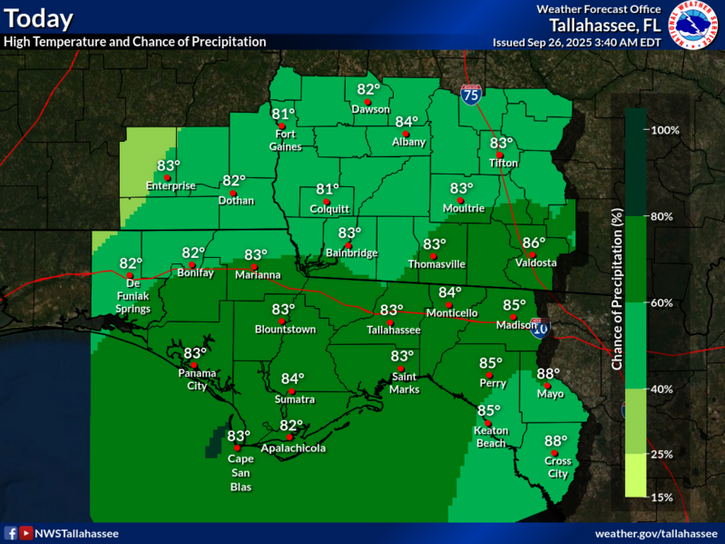
Temperatures today will reach near 88°F, but cooler conditions are expected over the weekend, in the mid-80s, due to persistent cloud cover and showers.
Today
A 70 percent chance of showers and thunderstorms, mainly after noon. Mostly cloudy, with a high near 88. Light northeast wind. New rainfall amounts between a quarter and half of an inch possible.
Tonight
A 60 percent chance of showers and thunderstorms, mainly before midnight. Mostly cloudy, with a low around 72. Light east wind.
Saturday
Showers and thunderstorms likely. High near 85. Light east wind. Chance of precipitation is 80%. New rainfall amounts between a quarter and half of an inch possible.
Saturday Night
A 50 percent chance of showers and thunderstorms. Mostly cloudy, with a low around 71. Calm wind.
Sunday
A 40 percent chance of showers and thunderstorms. Partly sunny, with a high near 86. Calm wind becoming south around 5 mph.
Copyright 2023-2025 FloridaWord.com


