National Weather Service Miami South Florida Rain Chances
MIAMI, FL — The National Weather Service in Miami has issued a forecast of scattered to numerous showers and thunderstorms across South Florida today, Thursday, August 28, 2025, with rain chances favoring the interior areas amid near-normal temperatures.
A few storms may become strong to marginally severe this afternoon into evening, capable of producing gusty and erratic winds, heavy downpours, and frequent lightning. Excessive rainfall could lead to localized urban and poor drainage flooding, with reduced visibility.
Temperatures will reach 90 to 94°F, with high humidity amplifying heat indices over 100°F, potentially approaching 108°F.
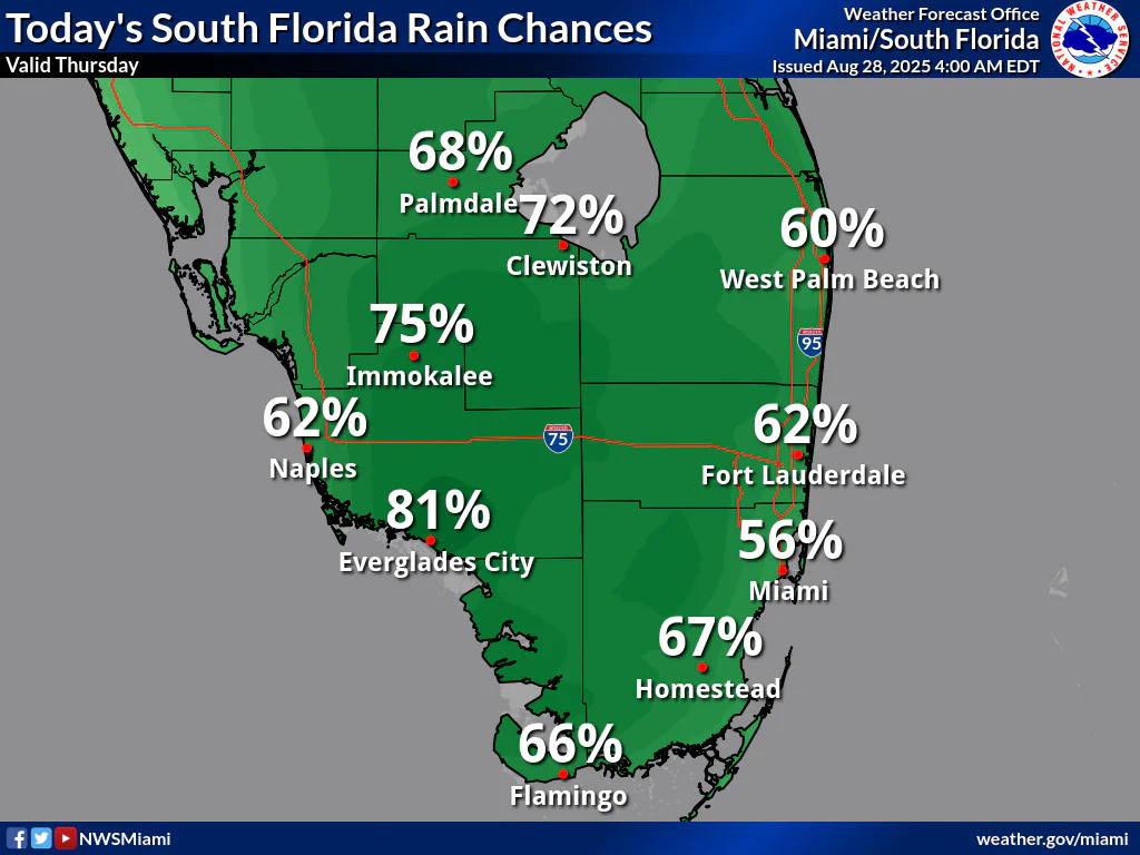
Rainfall chances today are moderate to high, with Palmdale at 68%, Clewiston at 72%, West Palm Beach at 60%, Immokalee at 75%, Naples at 62%, Everglades City at 81%, Fort Lauderdale at 62%, Miami at 56%, Homestead at 67%, and Flamingo at 66%, according to the NWS forecast. These probabilities show scattered to numerous shower and thunderstorm activity across South Florida, with potential for localized heavy rainfall.
Storm Timing:
Possible Hazards:
National Weather Service Miami South Florida Doppler Radar
Today
A chance of showers and thunderstorms, mainly this afternoon. Mostly sunny, with a high near 91°F. Heat index values as high as 103°F. Southeast wind 6 to 10 mph. Chance of precipitation is 60%. New rainfall amounts between a quarter and half of an inch possible.
Tonight
A 30 percent chance of showers and thunderstorms, mainly before 9pm. Mostly cloudy, with a low around 82°F. Southeast wind around 6 mph.
Friday
A 40 percent chance of showers and thunderstorms, mainly after 2pm. Mostly sunny, with a high near 91°F. Heat index values as high as 103°F. Southeast wind 6 to 10 mph.
Friday Night
A 30 percent chance of showers and thunderstorms, mainly before 8pm. Mostly cloudy, with a low around 82°F. Southeast wind 3 to 6 mph.
Saturday
A 40 percent chance of showers and thunderstorms after 2pm. Mostly sunny, with a high near 91°F. Light and variable wind becoming southeast 5 to 7 mph in the morning.
Saturday Night
A 30 percent chance of showers and thunderstorms. Mostly cloudy, with a low around 82°F. Southeast wind around 6 mph.
Copyright 2023-2025 FloridaWord.com


